Gesamtpreis (1 Artikel Artikel):
Versandziel:

jan janssonius (174 Ergebnisse)
Direkt zu den wichtigsten Suchergebnissen
Produktart
- Alle Produktarten
- Bücher (83)
- Magazine & Zeitschriften
- Comics
- Noten
- Kunst, Grafik & Poster (6)
- Fotografien
- Karten (85)
-
Manuskripte &
Papierantiquitäten
Zustand
- Alle
- Neu
- Antiquarisch/Gebraucht
Einband
- alle Einbände
- Hardcover (84)
- Softcover
Weitere Eigenschaften
- Erstausgabe (1)
- Signiert (1)
- Schutzumschlag
- Angebotsfoto (151)
Land des Verkäufers
Verkäuferbewertung
-
Bayern auf alten Landkarten aus dem Novus Atlas Absolutissimus von Johann Jansson.
Verlag: München, Battenberg 1978 (ca.), 1978
Anbieter: Buch- und Kunst-Antiquariat Flotow GmbH, Ottobrunn, Deutschland
Bewertung:

Der historische und kulturelle Hintergrund des Atlas Novus ist der Konkurrenzkampf zwischen den beiden Amsterdamer Landkartenverlegern Hondius-Jansson und Joan Blaeu. Amsterdam war damals die Hauptstadt der noch jungen Republik der Vereinigten Niederlande nach der Loslösung der protestantischen Provinzen von Spanien. - In dieser vollständigen Faksimile-Ausgabe enthalten sind mehrere Karten von Deutschland, Bayern, Franken, Umgebung von Nürnberg, Schwaben, der Rheinpfalz, Tirol, Salzburg, der Donauländer, Henneberg und Wertheim. - In sauberer Erhaltung 14 (1 gefalt.) farbige Landkarten-Faksimiles, 22 Blätter überwiegend faksimiliereter Begleittext Original-Halbleinen mit Buntpapierbezug, Imp.Folio.
-
Hondius. - "Descriptio Fluminum Rheni, Vahalis et Mosae a Rheno Berca ad Goricomium usque, comprehendens Imperium Noviomagense, Bataviam, Tielae et Bomelij insulas, regionesque conterminas". Original Kupferstichkarte.
Erscheinungsdatum: 1642
Anbieter: Treptower Buecherkabinett Inh. Schultz Volha, Berlin, Deutschland
Bewertung:
Buch
Amsterdam Hondius / Janssonius, 1642. Blattgröße ca. 46 x 57 cm .- Original Kupferstichkarte aus: Jan Janssonius, Newer Atlas. - Außenrand etwas fleckig, leicht wellig mit Faltspuren CG-1 Sprache: Deutsch Gewicht in Gramm: 2000.
-

Herefordia Comitatus vernacule Hereford Shire
Verlag: P. Schenk & G. Valk c.1700, Amsterdam, 1700
Anbieter: Alexandre Antique Prints, Maps & Books, Toronto, ON, Kanada
Bewertung:

Karte
Zustand: Very Good. A decorative map of Herefordshire, England, during the turn of the 17th century. The map shows roadways, cities, and geographical features. The map has a decorative cartouche, illustrations of various coats of arms and cherubs in the top right corner and cherubs and a man making use of the measurement legend in the bottom left corner. , Size : 376x495 (mm), 14.80x19.49 (Inches), Hand Colored.
-
Kein Einband. Zustand: Befriedigend. Ducatus Luneburgensis, anno 1647, Janssonius "DVCATVS LVNEBVRGENSIS Adiacentiump. regionum delineatio Auctore IOHANNE MELLINGERO" Altkolorierte Kupferkarte von Janssonius, anno 1647, franz. Rückentext. Sehr guter Erhaltungszustand, breitrandig, gedruckt auf dickem Papier, Blatt: 50x60 cm. Im Norden die Elbe mit Hamburg, im Südosten Magdeburg und im Südwesten die Weser mit Hameln.
-
Territorium Francofurtense
Verlag: Amsterdam, ca. 1647., 1647
Large folio. Nice original copper engraving , old - colouring. Very good copy of this map of the Frankfort region. 2 cartouches.
-
Geographia Sacra
Verlag: c.1630, Amsterdam, 1630
Anbieter: Alexandre Antique Prints, Maps & Books, Toronto, ON, Kanada
Bewertung:
Karte
Zustand: Very Good. Size : 363x484 (mm), 14.29x19.06 (Inches), Black & White.
-
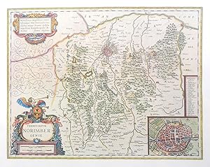
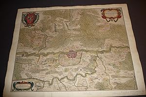
Territorii Novoforensis in superiore palatinatu accurata descriptio. Auct. Nicolao Rittershusio D.
Kunst / Grafik / Poster
( wohl aus aus: Novus Atlas, sive Theatrum orbis terrarum", die Karte ohne Rückentext, wohl um 1660 ) Bildmaß der Darstellung ca. 40 x 50 cm ( Höhe x Breite ), in älterer Zeit offenbar neu auf Büttenpapier montiert, Blattmaß gesamt ca. 53 x 64 cm. Die unkolorierte Karte mit Titelkartusche, einigen Wappen im Kartenbild und Meilenzeiger. Gezeigt wird oben links Nürnberg, mittig Neumarkt, rechterhand Rammersberg, unten Berching. Die Karte in der Darstellung minimal fleckig, am Oberrand mit hinterlegtem kleinen Einriß, ansonsten guter Zustand. Der weiße Außenrand des Büttenpapiers etwas fleckig, stock- und fingerfleckig sowie mit Randläsionen. ( Lagerort Große Graphikmappe Diverse AZ ) ( Weitere Bilder auf Anfrage further pics at request ).
-
Africae Propriae Tabula. In qua Punica regna uides. Tyrios.
Verlag: c.1630, Amsterdam, 1630
Anbieter: Alexandre Antique Prints, Maps & Books, Toronto, ON, Kanada
Bewertung:
Karte
Zustand: Very Good. Size : 376x525 (mm), 14.80x20.67 (Inches), Black & White.
-
Imperium Caroli Magni
Verlag: c.1630, Amsterdam, 1630
Anbieter: Alexandre Antique Prints, Maps & Books, Toronto, ON, Kanada
Bewertung:
Karte
Zustand: Very Good. Size : 370x530 (mm), 14.57x20.87 (Inches), Black & White.
-
Latium
Verlag: c.1630, Amsterdam, 1630
Anbieter: Alexandre Antique Prints, Maps & Books, Toronto, ON, Kanada
Bewertung:
Karte
Zustand: Very Good. Size : 358x492 (mm), 14.09x19.37 (Inches), Black & White.
-
Insularum Britannicarum Acurata Delineatio.
Verlag: c.1630, Amsterdam, 1630
Anbieter: Alexandre Antique Prints, Maps & Books, Toronto, ON, Kanada
Bewertung:
Karte
Zustand: Very Good. Size : 395x514 (mm), 15.55x20.24 (Inches), Hand Colored.
-
Attica.Mecarica.Corinthiaca.Boeotia.Phocis.Locri.
Verlag: c.1630, Amsterdam, 1630
Anbieter: Alexandre Antique Prints, Maps & Books, Toronto, ON, Kanada
Bewertung:
Karte
Zustand: Very Good. Size : 365x495 (mm), 14.37x19.49 (Inches), Black & White.
-
Hispaniae Veteris Descriptio.
Verlag: c.1630, Amsterdam, 1630
Anbieter: Alexandre Antique Prints, Maps & Books, Toronto, ON, Kanada
Bewertung:
Karte
Zustand: Very Good. Size : 375x495 (mm), 14.76x19.49 (Inches), Black & White.
-
Europam; sive Celticam veterem
Verlag: c.1630, Amsterdam, 1630
Anbieter: Alexandre Antique Prints, Maps & Books, Toronto, ON, Kanada
Bewertung:
Karte
Zustand: Very Good. Size : 357x476 (mm), 14.06x18.74 (Inches), Hand Colored.
-
Erythraeum Sive Rubrum Mare.Alexandri Magni Macedonis Expeditio.
Verlag: c.1630, Amsterdam, 1630
Anbieter: Alexandre Antique Prints, Maps & Books, Toronto, ON, Kanada
Bewertung:
Karte
Zustand: Very Good. Size : 369x470 (mm), 14.53x18.50 (Inches), Hand Colored.
-
Opakh. Thraciae Veteris Typus.
Verlag: c.1630, Amsterdam, 1630
Anbieter: Alexandre Antique Prints, Maps & Books, Toronto, ON, Kanada
Bewertung:
Karte
Zustand: Very Good. Size : 363x488 (mm), 14.29x19.21 (Inches), Hand Colored.
-
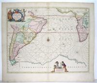
Mar Di Aethiopia Vulgo Oceanus Aethiopicus.
Verlag: Amsterdam, 1650
Anbieter: Alexandre Antique Prints, Maps & Books, Toronto, ON, Kanada
Bewertung:
Karte
Zustand: Very Good. Engraved decorative chart showing most of South America and much of Africa from Atlas Novus, in the Vol. 5. (Water World)., Size : 439x553 (mm), 17.25x21.75 (Inches), Original Hand Coloring, 0.
-
Italiae Antiquae Nova Delinatio.
Verlag: c.1630, Amsterdam, 1630
Anbieter: Alexandre Antique Prints, Maps & Books, Toronto, ON, Kanada
Bewertung:
Karte
Zustand: Very Good. Size : 385x505 (mm), 15.16x19.88 (Inches), Hand Colored.
-
Descriptio Peregrinationis D. Pauli, Apostoli.
Verlag: c. 1640, Amsterdam, 1640
Anbieter: Alexandre Antique Prints, Maps & Books, Toronto, ON, Kanada
Bewertung:
Karte
Zustand: Very Good. Striking map of the Mediterranean and its surrounding areas. It depicts the travels of St. Paul. The decorative cartouche, presented in a curtain style design, follows the incidences St. Paul faced during his travels. Capsized ships are depicted in the map, one being attacked by a sea monster. , Size : 368x516 (mm), 14.50x20.30 (Inches), Hand Colored.
-
Ćgyptvs Antiqva Divifa in Nomos.
Verlag: c. 1650, Amsterdam, 1650
Anbieter: Alexandre Antique Prints, Maps & Books, Toronto, ON, Kanada
Bewertung:
Karte
Zustand: Very Good. Striking large scale map of Egypt with the course of the Nile. Depicted clearly are the boundaries of various local provinces. In Latin with a note in French. Includes a note in a decorative cartouche: \\\\\\\"A Monsieur Monsieur Doviat Sgr. de Montreuille, Con.er du Roy, et Maistre Ordinaire en sa Chambre des Comptes Par son Trčs humble et obéisant Serviteur P. Duval Géographe de sa Maiesté\\\"., Size : 394x521 (mm), 15.50x20.50 (Inches), Hand Colored.
-
Italia Gallica, Sive Gallia Cisalpina, Ex conatibus Geographicis Abrah. Ortelij.
Verlag: c. 1662, Amsterdam, 1662
Anbieter: Alexandre Antique Prints, Maps & Books, Toronto, ON, Kanada
Bewertung:
Karte
Zustand: Very Good. Striking detailed map of Southernh Italy. \"Cartouche on left hand side has 6 lines of placenames, while the cartouche on the bottom right corner has two columns of 12 people of uncertain location. This map is based on ancient knowledge from Livius, Ausonius, Tacitus, Cato, Plinius, Polybius and Cassiodore\\\\\\\". (Tooley, p. 258), Size : 349x465 (mm), 13.75x18.30 (Inches), Hand Colored.
-
Aeneae Troiani Navigatio Ad Virgilij sex priores Aeneidos
Verlag: c. 1640, 1640
Anbieter: Alexandre Antique Prints, Maps & Books, Toronto, ON, Kanada
Bewertung:
Karte
Zustand: Very Good. A map of the Mediterranean from Troy to Italy. Designed with two decorative cartouches, one of which includes a passage from the Roman epic The Aeneid, as well as a large inset map in the upper right corner. A group of capsized ships are depicted near Libya. , Size : 394x495 (mm), 15.50x19.50 (Inches), Hand Colored.
-
(Stolen)Imperium Romanum Auth Phil. Briet e Societ Iesu.
Verlag: c. 1640, Amsterdam, 1640
Anbieter: Alexandre Antique Prints, Maps & Books, Toronto, ON, Kanada
Bewertung:
Karte
Zustand: Very Good. (Stolen)Jansson's striking map of the Roman Empire. It was first issued based upon an earlier map of Briet, in the 1650s. The map includes an inset of the area around Rome., Size : 387x523 (mm), 15.25x20.60 (Inches), Hand Colored.
-
Regni Norvegiae. Nova et Accurata descriptio.
Amsterdam omkr. 1664. 42,5x53. Tćt skĺret indtil pladenranden, men intet tab. Kobberstukket og i samtidig hĺndkolorering. Kartouche med skovarbejdere, kompasrose, skibe i sřen.orienteret med řst řverst. Udmćrket eksemplar af et af de tidligste folio-kort over Norge.
-
Cambriae Typus auctore Humfredo Lluydo Denbigiense Cambro britanno.
Verlag: c.1640, Amsterdam, 1640
Anbieter: Alexandre Antique Prints, Maps & Books, Toronto, ON, Kanada
Bewertung:
Karte
Zustand: Very Good. Decorated with a gathering of Puttos bearing fruit and charting the Planet\\\\\\\'s movements. A compass-rose stands alone to the left, with various ships and one sea monster placed along the ocean. , Size : 343x490 (mm), 13.50x19.30 (Inches), Hand Colored.
-
Pascaarte Van't Westlyckste Deel vande Middelandsche Zee.: Pascaarte Van't Oostelyckste Deel vande Middelandsche Zee.
Verlag: c. 1650, Amsterdam, 1650
Anbieter: Alexandre Antique Prints, Maps & Books, Toronto, ON, Kanada
Bewertung:
Karte
A fine pair of mid-17th century see charts showing the Western and Eastern sides of the Mediterranean, by Jansson, depicting the Straits of Gibraltar in the West (on the first sheet) all the way to Syria and Palestine in the East (on the second sheet). The maps cover Spain, France, Corsica, Sardinia, Italy, Greece, Romania, Syria, Cyprus and parts of the Holy Land. The maps are from Jansson\\\'s Atlantis Majoris, the first commonly circulated sea atlas of the world published in the NetherlandsBoth maps include colourful and decorative cartouches; the Western map with a Nobleman and a bear chested Native holding up a cornucopia of fruit with a crown on top, the Eastern map with two Middle Eastern men dressed in layered garments,The measuring charts are housed in two dragon-like figures (Western) and ornamental frame (Eastern). Two fleur-de-lis compasses are also shown on each map. Latin text on verso.The sizes of the two maps are:418 x 540 (Eastern Sheet)418 x 532 (Western Sheet), Size : 418x540 (mm), 16.46x21.26 (Inches), Original Outline Coloring Occasional minor browning otherwise Very Good.
-
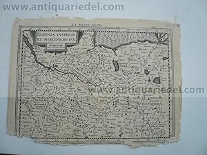
Saxonia Inferior et Meklenborg duc. Kupferstich von P. Kaerius
Verlag: Janssonius Jan,1588-1664, 1664
Hardcover. Zustand: very good. Saxonia Inferior et Meklenborg duc. Kupferstich von P. Kaerius bei J. Janssonius, Amsterdam, 1630, 14 x 20 cm. Aus G. Mercator, "Atlas Minor", französische Ausgabe. - Karte mit den Herzogtümern Lüneburg und Lauenburg, Mecklenburg, Pommern und der Mark Brandenburg. Im Norden die Ostsee von Travemünde bis Wolgast, im Süden Celle und Spandau, im Westen Walsrode, im Osten Templin. DIVERSE RANDLÄSUREN,geringer Bildverlust, einige Wurmlöchlein.
-
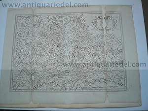
Hardcover. Zustand: very good. Donaulauf anno 1640, Janssonius J., bis Belgrad, Kupferkarte, 45x50 cm., auf Trägerkarton aufgezogen, am Fuß grössere Fehlstellen/Bildverlust.
-
Hardcover. Zustand: very good. Salzburg/Kärnten, anno 1640, Karte, Janssonius J., alt auf Trägerkarton aufgezogen, 35x47 cm., beschädigt mit Bildverlust.
-
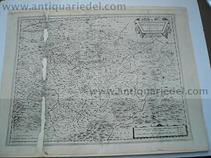
Westphalia Ducatus, anno 1640, Karte Janssonius, Janssonius, J.
Verlag: Janssonius Jan,1588-1664, 1664
Hardcover. Zustand: very good. Westphalia Ducatus, anno 1640, Karte Janssonius, Janssonius, J. Westphalia Ducatus. Amstelodami, Excudebat Ioannes Ianssonius. 38 x 50 cm. Auf Karton aufgezogen. Schöne Kupferstich Landkarte von Westphalen von J. Janssonius. Mit zwei schönen Kartuschen. Zeigt die Gegend zwischen Essen, Olpe, Landau und Lippe mit Meschede im Zentrum. Links stark beschädigt mit Bildverlust.