
Gesamtpreis (1 Artikel Artikel):
Versandziel:

probst johann michael (9 Ergebnisse)
Feedback
Direkt zu den wichtigsten Suchergebnissen
Suchfilter
Produktart
- Alle Product Types
- Bücher (2)
- Magazine & Zeitschriften (Keine weiteren Ergebnisse entsprechen dieser Verfeinerung)
- Comics (Keine weiteren Ergebnisse entsprechen dieser Verfeinerung)
- Noten (Keine weiteren Ergebnisse entsprechen dieser Verfeinerung)
- Kunst, Grafik & Poster (Keine weiteren Ergebnisse entsprechen dieser Verfeinerung)
- Fotografien (Keine weiteren Ergebnisse entsprechen dieser Verfeinerung)
- Karten (7)
- Manuskripte & Papierantiquitäten (Keine weiteren Ergebnisse entsprechen dieser Verfeinerung)
Zustand
- Alle
- Neu (Keine weiteren Ergebnisse entsprechen dieser Verfeinerung)
- Antiquarisch (9)
Einband
- alle Einbände
- Hardcover (1)
- Softcover (Keine weiteren Ergebnisse entsprechen dieser Verfeinerung)
Weitere Eigenschaften
- Erstausgabe (Keine weiteren Ergebnisse entsprechen dieser Verfeinerung)
- Signiert (Keine weiteren Ergebnisse entsprechen dieser Verfeinerung)
- Schutzumschlag (Keine weiteren Ergebnisse entsprechen dieser Verfeinerung)
- Angebotsfoto (9)
Sprache (2)
Preis
- Beliebiger Preis
- Weniger als EUR 20 (Keine weiteren Ergebnisse entsprechen dieser Verfeinerung)
- EUR 20 bis EUR 45 (Keine weiteren Ergebnisse entsprechen dieser Verfeinerung)
- Mehr als EUR 45
Gratisversand
- Kostenloser Versand nach USA (Keine weiteren Ergebnisse entsprechen dieser Verfeinerung)
Land des Verkäufers
Verkäuferbewertung
-

Neue Post Karte von Bayern.
Verlag: Augsburg, 1797., 1797
Anbieter: Antiquariat INLIBRIS Gilhofer Nfg. GmbH, Vienna, A, Österreich
Verbandsmitglied: ILAB VDA VDAO
Verkäuferbewertung 5 von 5 Sternen

EUR 500,00
Währung umrechnenEUR 30,00 für den Versand von Österreich nach USAAnzahl: 1 verfügbar
In den Warenkorb570 x 510 mm. Gestochene Karte in 16 Segmenten, auf Leinen aufgezogen und gefaltet.
-

Italien in seine unterschiedene Laender eingetheilet
Verlag: Probst, Augsburg, 1780
Anbieter: Antikvariat Krenek, Prag, Tschechien
Verbandsmitglied: ILAB
Verkäuferbewertung 5 von 5 Sternen
Karte
EUR 125,01
Währung umrechnenEUR 14,50 für den Versand von Tschechien nach USAAnzahl: 1 verfügbar
In den WarenkorbKein Einband. Zustand: Gut bis sehr gut. Italy. "Italien in seine unterschiedene Laender eingetheilet". Orig. copperplate engraving, J. M. Probst, Augsburg, ca. 1780. Engraved by J. G. Probst. Orig. old colouring. With decorative title cartouche and explanatory notes on the right. 17,5:25 cm (6 3/4 x 9 3/4 inch.). A map of Italy.
-

Gros Britan . oder Engelland
Verlag: Probst, Augsburg, 1785
Anbieter: Antikvariat Krenek, Prag, Tschechien
Verbandsmitglied: ILAB
Verkäuferbewertung 5 von 5 Sternen
Karte
EUR 166,68
Währung umrechnenEUR 14,50 für den Versand von Tschechien nach USAAnzahl: 1 verfügbar
In den WarenkorbKein Einband. Zustand: Gut bis sehr gut. Great Britain and Ireland. "Gros Britan. oder Engelland, Schot zu Irrla.". Orig. copperplate engraving. Engraved by J. G. Probst, 1785, published by J. M. Probst in Augsburg. Orig. old colouring. With decorative title cartouche wit a coat of arms, inset map of Orkney Islands, a wind rose and explanatory notes on the right. 16:23,5 cm (6 1/4 x 9 1/4 inch.). A map of Great Britain and Ireland.
-
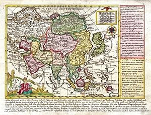
Asia verlegt von Ioh. Mich. Probst
Verlag: Probst, Augsburg, 1785
Anbieter: Antikvariat Krenek, Prag, Tschechien
Verbandsmitglied: ILAB
Verkäuferbewertung 5 von 5 Sternen
Karte
EUR 250,02
Währung umrechnenEUR 14,50 für den Versand von Tschechien nach USAAnzahl: 1 verfügbar
In den WarenkorbKein Einband. Zustand: Sehr gut. Asia. "Asia verlegt von Ioh. Mich. Probst". Orig. copperplate engraving. Published by J. M. Probst in Augsburg, ca. 1785. Orig. old colouring. With figure title cartouche and a cartouche with the scale of map, a wind rose and explanatoty notes on the right and under the map. 15,5:19 cm (6 1/4 x 7 1/2 inch. - the map); 18:24 cm (7 x 9 1/2 inch. - whole plate, including explanatory notes). A map of Asia.
-

Der Fraenkische Kreis
Verlag: Probst, Johann Michael, Augsburg, 1789
Anbieter: Antikvariat Krenek, Prag, Tschechien
Verbandsmitglied: ILAB
Verkäuferbewertung 5 von 5 Sternen
EUR 270,86
Währung umrechnenEUR 14,50 für den Versand von Tschechien nach USAAnzahl: 1 verfügbar
In den WarenkorbBayern. Franken. "Der Fraenkische Kreis. Nach seiner dermaligen Länder Eintheilung". Altkol. kupferstich Karte bei J. M. Probst, Augsburg, 1789. Gest. von J. G. Probst. Mit dekorative Titelkart., kl. Nebenkarte (9:7 cm), Meilenanzeiger und Erklärungen. 50:57 cm. In der oberen linken Ecke und am linken Rand handschriftliche Bemerkungen aus dem frühen 19. Jahrhundert. - Karte von Franken mit befestigte Städte (u. a. Würzburg, Bamberg, Nürnberg, Regensburg).
-

Africa verlegt von Ioh. Mich. Probst
Verlag: Probst, Augsburg, 1785
Anbieter: Antikvariat Krenek, Prag, Tschechien
Verbandsmitglied: ILAB
Verkäuferbewertung 5 von 5 Sternen
Karte
EUR 291,69
Währung umrechnenEUR 14,50 für den Versand von Tschechien nach USAAnzahl: 1 verfügbar
In den WarenkorbKein Einband. Zustand: Gut bis sehr gut. Africa. "Africa verlegt von Ioh. Mich. Probst". Orig. copperplate engraving. Published by J. M. Probst in Augsburg, ca. 1785. Orig. old colouring. With figure title cartouche and a cartouche with the scale of map, explanatoty notes on the right and under the map. 16:20,5 cm (6 1/4 x 8 inch. - the map); 18:24 cm (7 x 9 1/2 inch. - whole plate, including explanatory notes). A map of Africa.
-

Asia verlegt von Ioh. Mich. Probst
Verlag: Probst, Augsburg, 1785
Anbieter: Antikvariat Krenek, Prag, Tschechien
Verbandsmitglied: ILAB
Verkäuferbewertung 5 von 5 Sternen
Karte
EUR 333,36
Währung umrechnenEUR 14,50 für den Versand von Tschechien nach USAAnzahl: 1 verfügbar
In den WarenkorbKein Einband. Zustand: Gut bis sehr gut. America. "America verlegt von Ioh. Mich. Probst". Orig. copperplate engraving. Published by J. M. Probst in Augsburg, ca. 1785. Orig. old colouring. With figure title cartouche and a cartouche with the scale of map, a wind rose and explanatoty notes on the right and under the map. 16,5:19,5 cm (6 1/2 x 7 3/4 inch. - the map); 18,5:23,5 cm (7 1/4 x 9 1/4 inch. - whole plate, including explanatory notes). Map of America.
-

Das Königreich Napoli in dessen XII Haupt Provinciien, Nachdenen Neuesten Observationen Magini, Greüters, Sansons, De Fer Nolin, Cantelli, &c.
Erscheinungsdatum: 1775
Anbieter: Altea Antique Maps, London, Vereinigtes Königreich
Verbandsmitglied: ABA ILAB PBFA
Verkäuferbewertung 5 von 5 Sternen
Karte
EUR 698,25
Währung umrechnenEUR 40,91 für den Versand von Vereinigtes Königreich nach USAAnzahl: 1 verfügbar
In den WarenkorbAugsburg, c.1775. Original colour. 450 x 550mm. An uncommon map of Italy south of Rome, with elaborate cartouches for the title scale and key.
-
Circulus Suevicus in quo sunt Ducatus Wirtenbergensis, Marchionatus Badensis, & Burgoviensis, Comitatus Otting, Rechberg, Konigsek, Hohenzollern, & Furstenberg, Baronatus Limburg, Waldburg, & Iustingen, Status Domus Fuggerorum, Episcopatus Augustae, & Constantiae, Abbatia Kemptensis, et Territorium Ulmense. in lucem edita per Ioh. Michael Probst Chalcogr. Aug. Vind. - Joh. Michael Probst excud. Aug. Vind.
Erscheinungsdatum: 1785
Sprache: Deutsch
Anbieter: Kunstantiquariat Andreas Senger, Hamburg, Deutschland
Verkäuferbewertung 4 von 5 Sternen

Karte
EUR 999,00
Währung umrechnenEUR 35,00 für den Versand von Deutschland nach USAAnzahl: 1 verfügbar
In den WarenkorbKein Einband. Zustand: Gut. Es handelt sich hierbei um eine originale, kolorierte Kupferstich-Landkarte des Herzogtums Württemberg von Abraham Ortelius (1527 - 1598) aus dem Jahr 1579. *** Titel: Circulus Suevicus in quo sunt Ducatus Wirtenbergensis, Marchionatus Badensis, & Burgoviensis, Comitatus Otting, Rechberg, Konigsek, Hohenzollern, & Furstenberg, Baronatus Limburg, Waldburg, & Iustingen, Status Domus Fuggerorum, Episcopatus Augustae, & Constantiae, Abbatia Kemptensis, et Territorium Ulmense. in lucem edita per Ioh. Michael Probst Chalcogr. Aug. Vind. - Joh. Michael Probst excud. Aug. Vind.':. *** Gebiet bzw. Ort: Baden-Württemberg und der bayerische Regierungsbezirk Schwaben *** Kartograph: Johann Michael Probst (1727 - 1776) *** Jahr: 1785 *** Größe des Plattenbereichs: 49 x 56 cm *** Technik: Kupferstich *** Zustand (Perfekt/ Sehr gut/ Gut/ Ordentlich/ Mäßig/ Schlecht): In gutem Erhaltungszustand. Insgesamt altersgemäß leicht gebräunt. Unauffällige, geglättete horizontale Falte *** Bemerkungen: Sehr seltene Landkarte Baden-Württembergs und des heutigen bayerischen Regierungsbezirks Schwaben in dekorativem Altkolorit. Das dargestellte Gebiet erstreckt sich von Heidelberg im Norden über Straßburg im Westen und den Bodensee im Süden bis Augsburg im Osten. Der äußerst detaillierte Kartenbereich wird durch eine aufwendige Wappenkartusche mit Figurenstaffage ergänzt. Referenz: Tooley's Dic. of Mapm. Rev. Ed. K - P, S. 463. - - - International buyers welcome. If you have any questions, please don't hesitate to ask. --- Auf Wunsch stellen wir Ihnen gerne ein kostenfreies Echtheitszertifikat aus --- If you wish, we will gladly provide a certificate of authenticity free of charge ---.
