
Gesamtpreis (1 Artikel Artikel):
Versandziel:

Karten, rio janeiro (91 Ergebnisse)
Feedback
Direkt zu den wichtigsten Suchergebnissen
Suchfilter
Produktart
Zustand
Einband
Weitere Eigenschaften
- Erstausgabe (7)
- Signiert (Keine weiteren Ergebnisse entsprechen dieser Verfeinerung)
- Schutzumschlag (Keine weiteren Ergebnisse entsprechen dieser Verfeinerung)
- Angebotsfoto (86)
Sprache (4)
Gratisversand
- Kostenloser Versand nach USA (Keine weiteren Ergebnisse entsprechen dieser Verfeinerung)
Land des Verkäufers
Verkäuferbewertung
-

Rio de Janeiro. 1 alte Orig.- Ansichtspostkarte
Verlag: Rio de Janeiro, 1913
Anbieter: Klaus Kreitling, Berlin, Deutschland
Verkäuferbewertung 4 von 5 Sternen

Karte
EUR 1,15
Währung umrechnenEUR 45,00 für den Versand von Deutschland nach USAAnzahl: 1 verfügbar
In den WarenkorbKein Einband. Zustand: Gut. Lichtdruck. Postalisch beförderte Karte. Marke und Stempel sind vorhanden. Schnellster Versand ist möglich. Erhaltungszustand:
-

Brazil Map
Verlag: National Geographic Maps Jan 2022, 2022
ISBN 10: 1566955459 ISBN 13: 9781566955454
Sprache: Englisch
Anbieter: AHA-BUCH GmbH, Einbeck, Deutschland
Verkäuferbewertung 5 von 5 Sternen

Karte
EUR 18,57
Währung umrechnenEUR 28,47 für den Versand von Deutschland nach USAAnzahl: 1 verfügbar
In den WarenkorbKarte. Zustand: Neu. Neuware - AdventureMaps are the most authoritative maps for touring international destinations. The front side of the Brazil map includes the western half of the country and features the remarkable Amazon Basin and the Mato Grosso Plateau, as well as airports, airfields, anchorages, and other travel aids invaluable for adventurers seeking to explore the tropical rainforests, savannahs, and woodlands at the heart of the country's interior. The eastern half of the country is covered on the reverse, including the capital of Brasilia and the cities of Sao Paulo, Rio de Janeiro, Salvador and more.
-

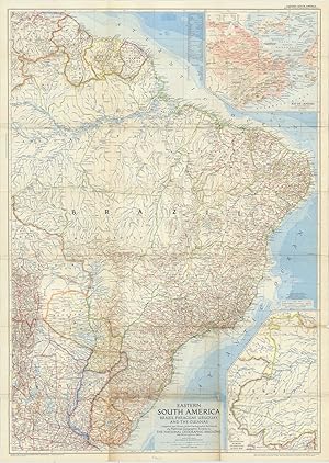
Brazil, Paraguay, Uruguay and the Guianas. Compiled and Drawn in the Cartographic Section of the National Geographic Society for the National Geographic Magazine. John Oliver LaGorce, Editor. Map supplement to The National Geographic Magazine, Vol.CVII, No.3.
Verlag: Washington, National Geographic Society, March 1955., 1955
Sprache: Englisch
Anbieter: Antiquariat Gerber AG, ILAB/VEBUKU/VSAR, Basel, Schweiz
Verkäuferbewertung 4 von 5 Sternen
Karte Erstausgabe
EUR 15,00
Währung umrechnenEUR 42,00 für den Versand von Schweiz nach USAAnzahl: 1 verfügbar
In den WarenkorbMehrfach gefaltete Karte, farbig // Multiple folded map in color. With inset: Rio de Janeiro, Continuation of Brazil on same scale as main map /// Outer foldings with light browning. Sprache: Englisch Gewicht in Gramm: 60 15,5 x 24,5 cm (entfaltet/unfolded 102 x 73,5 cm).
-
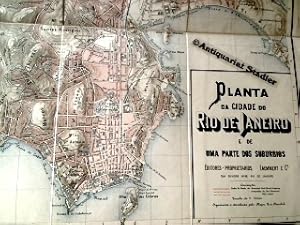
Planta do Cidade do Rio de Janeiro e de uma parte dos suburbios. (Republica dos Estados Unidos do Brazil). Gravura de Giesecke & Devrient, Leipzig.
Verlag: Rio de Janeiro: Laemmert [1890]., 1890
Sprache: Deutsch
Anbieter: Antiquariat im Kloster, Weilheim, BY, Deutschland
Verkäuferbewertung 5 von 5 Sternen
Karte
EUR 650,00
Währung umrechnenEUR 45,00 für den Versand von Deutschland nach USAAnzahl: 1 verfügbar
In den WarenkorbZustand: Befriedigend. Mehrfarb. Faltkarte in 8 Segmenten auf Leinen gezogen. 43,5 x 54 cm. Maßstab: 1:20.000. - SEHR SELTEN! - Ebd. stärker fleckig, Leinen rückwärtig fleckig, insgesamt sehr schönes Exemplar. Zahlungen mit PayPal möglich. Sprache: Deutsch Gewicht in Gramm: 330 Landkarte mit OLeinenbd. m. Goldpräg. Faltmaß 23x14 cm.
-
Guia e Planta da Cidade do Rio de Janeiro.
Verlag: Rio de Janeiro (Soria & Boffoni), 1922
Anbieter: Antiquariat A. Suelzen, Berlin, Deutschland
Verkäuferbewertung 5 von 5 Sternen
Karte
EUR 280,00
Währung umrechnenEUR 29,00 für den Versand von Deutschland nach USAAnzahl: 1 verfügbar
In den Warenkorb"Planta parcial da Cidade Rio de Janeiro", farbig lithographierter, gefalteter Stadtplan, 80 x 71 cm (mittig in zwei Hälften getrennt, ein Randausriss ohne Bildverlust); 66 S. Straßenverzeichnis. Orig.-Halbleinen-Mäppchen 15,5 x 11 cm (etw. fleckig, Klammerheftung rostig; innen sauber) * Umfassendes Straßenverzeichnis und Verzeichnis der wichtigsten Institutionen. Der gefaltete Stadtplan im Maßstab 1:15000. - Contendo muitas indicacoes uteis, os principaes passeios e vias de communicacoes indispensaveis. - Beiliegend: 1 gefalteter Innenstadtplan mit wichtigen Geschäftshäusern (Ausschnitt aus der deutschen Rio-Zeitung, ca. 1928).
-

EUR 9,90
Währung umrechnenEUR 70,00 für den Versand von Deutschland nach USAAnzahl: 1 verfügbar
In den Warenkorb(Land-)Karte. Zustand: Neu. Borch Map Brazil / Brasilien | Brazil, Fernando de Noronha Island, Amazonian Brazil, Brasília, Manaus, Rio de Janeiro Centre, Rio de Janeiro, Săo Paulo, Fortaleza, Natal, Recife, Salvador, Curitiba, Florianópolis, Porto Alegre. Markier- und abwischbar | (Land-)Karte | Mehrfarbendruck. Gefalzt | 2 S. | Deutsch | 2015 | Borch | EAN 9783866093645 | Verantwortliche Person für die EU: Borch GmbH, Markus Borch, Kollersberger Str. 44, 94051 Hauzenberg, info[at]borchmap[dot]com | Anbieter: preigu.
-
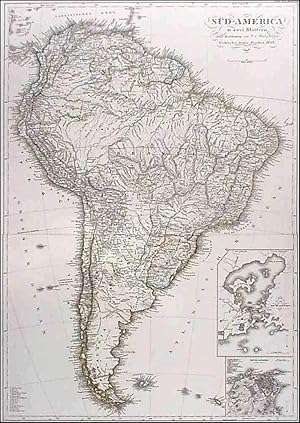
Süd-America in zwei Blättern [und] Der südliche Theil von Südamerika. - [Zwei kolorierte Karten aus dem Handatlas von Stieler].
Verlag: Gotha: Perthes o.O. (1859)., 1859
Sprache: Deutsch
Anbieter: ANTIQUARIAT Franke BRUDDENBOOKS, Lübeck, Deutschland
Verkäuferbewertung 5 von 5 Sternen
Karte
EUR 28,40
Währung umrechnenEUR 16,51 für den Versand von Deutschland nach USAAnzahl: 1 verfügbar
In den WarenkorbKupferstiche. Zustand: Gut. 2 Bl. ( jeweils 36 x 42 cm, gefaltet auf 36 x 21 cm), (= Stieler's Hand-Atlas No. 49c. Ausgabe mit 63 Blättern, Blatt No. LX und Blatt No. LXI). - Zwei grenzkolorierte Karten (Kupferstiche) von dem nördlichen und von dem südlichen Teil Südamerikas. - Eine Karte mit den beiden Nebenkarten "Bay von Rio de Janeiro" und "Rio de Janeiro". - Aus "Hand-Atlas über alle Theile der Erde nach dem neuesten Zustande und über das Weltgebäude" herausgegeben von Adolf Stieler. 6. Auflage. - Etwas fleckig. Sonst saubere und wohlerhaltene Exemplare. Wir senden umgehend mit beiliegender MwSt.Rechnung. Sprache: Deutsch Gewicht in Gramm: 1001.
-
Eastern South America: Brazil, Paraguay, Uruguay, and the Guianas Compiled and Drawn in the Cartographic Section of the National Geographic Society for the National Geographic Magazine,John Oliver La Gorce, Editor. Chamberlin Trimetric Projection, Scale 1:5,000,000 or 78.91 Miles to the Inch.
Verlag: Baltimore MdLithographed by A. Hoen and Co. March ., 1955
Anbieter: Robert Frew Ltd. ABA ILAB, London, Vereinigtes Königreich
Verbandsmitglied: ABA ILAB PBFA
Verkäuferbewertung 4 von 5 Sternen
Karte
EUR 60,64
Währung umrechnenEUR 11,77 für den Versand von Vereinigtes Königreich nach USAAnzahl: 1 verfügbar
In den WarenkorbColour printed map of Eastern South America: Brazil, Paraguay, Uruguay, and the Guianas (103 x 73.5 cm) folding to 24.5 x 15.5 cm. Showing railways, roads, Pan American Highway, airports, oil fields, oil pipe lines, elevations in feet, depth curves and soundings in fathoms. Also with inset maps showing Continuation of Brazil on Same Scale as Main Map and Rio de Janeiro. Old fold creases, minor browning and trivial nicks along some folds. Generally a very good example.
-
![Bild des Verkäufers für Brasilien 1857. [Hand-colored engraving of Brasil in 1857]. zum Verkauf von Magister Michalis, Internet-Antiquariat](https://pictures.abebooks.com/inventory/md/md19401991381.jpg)
Brasilien 1857. [Hand-colored engraving of Brasil in 1857].
Verlag: Bibliograph. Institut, Hildburghausen, 1857
Sprache: Deutsch
Anbieter: Magister Michalis, Internet-Antiquariat, Wielenbach, Deutschland
Verkäuferbewertung 5 von 5 Sternen
Karte
EUR 14,54
Währung umrechnenEUR 50,99 für den Versand von Deutschland nach USAAnzahl: 1 verfügbar
In den WarenkorbKein Einband. Zustand: Gut. o.J., ca. 1855. Stahlstich, Blattgröße ca. 29,5x24cm. Vierfarbig u. feinstens grenzkolorierte Karte (Original ohne spätere Nachzeichnungen). Mit einem Nebenkärtchen: Rio de Janeiro. +++ Steel engraving, original HAND COLORING in outline when published. Left upper corner taped professionally and contemporary at rear --- cf. photo. +++ Aus Nichtraucherhaushalt. +++ Mehr Infos gerne über die Schaltfläche 'Frage an den Anbieter'. +++ Rare.
-
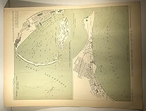
Map of Callao (1885) Map of Rio de Janeiro (1884). Atlas des ports étrangers.
Verlag: Imprimerie nationale, Paris, 1888
Anbieter: DACART Livres rares & manuscrits (ALAC), Saint-Lambert, QC, Kanada
Verkäuferbewertung 5 von 5 Sternen
Karte
EUR 130,81
Währung umrechnenEUR 21,95 für den Versand von Kanada nach USAAnzahl: 1 verfügbar
In den WarenkorbSheet. Zustand: Very good. Map of Callao (1885) and Map of Rio de Janeiro (1884). Colour. 2 maps on the same sheet. 28 x 22.5 cm. 11 x 8 ľ inches. From the "Atlas des ports étrangers". 4th serie. Maps showing the docks of Callao (Peru) and Rio de Janeiro (Brazil). Cartes.
-
The Illustrated London News Vol.28 Jan to Jun 1856
Verlag: Published by William Little, London, 1856
Anbieter: Keoghs Books, Skipton, Vereinigtes Königreich
Verbandsmitglied: PBFA
Verkäuferbewertung 4 von 5 Sternen
Karte Erstausgabe
EUR 272,86
Währung umrechnenEUR 32,97 für den Versand von Vereinigtes Königreich nach USAAnzahl: 1 verfügbar
In den Warenkorb, [2] 720 pages, articles include Fold out Plan of Crimea with engraving on rear and fold out Picture Map of the Baltic Sea with The Grand Naval Review engraving to rear; Naval engagement between Swedes and Russians; Ely Cathedral restored; New Music hall Covent Garden; Wreck of George Lord Isle of Wight; New Ballroom Buckingham Palace; Wreck of Polyphemus; Siege of Sebastopol; Birth of Prince Napoleon, France; Confirmation of Princess Royal at Windsor; Peace announced at Mansion House; The Grand Naval Review Supplement; Coloured plates "The Squire's Daughter, Staffordshire" by J. Absolon, "A Sketch in the Fruit Market at Rio de Janeiro" by J. Gilbert, "The Standard Bearer" by J. Gilbert, and "A Reaper, Worcestershire" by J. Absolon; Sepia engravings of Entertainment to Admiral Dundas on HMS Wellington, Saint Chapelle restored, Malta from a painting by J.B. Carmichael; Peace Commemoration; First Edition , rebound with original cloth laid down, light bumping to corners, missing p31/32, three coloured plates badly torn and grazed, small mark to one fold out plate, repaired tears to other, some page edges reinforced, pages clean, good condition , green blindstamped cloth, gilt illustration and title to front and spine, full gilt edges , 42 cm x 30 cm Hardback ISBN:
-

South America in Globular Perspective looking Northwest from a Height of about Eight Thousand Miles.
Verlag: New YorkTime Inc. ., 1937
Anbieter: Robert Frew Ltd. ABA ILAB, London, Vereinigtes Königreich
Verbandsmitglied: ABA ILAB PBFA
Verkäuferbewertung 4 von 5 Sternen
Karte
EUR 424,45
Währung umrechnenEUR 11,77 für den Versand von Vereinigtes Königreich nach USAAnzahl: 1 verfügbar
In den WarenkorbOriginal colour-printed pictorial map of South America in globular perspective (69 x 56.5 cm), with insets of Buenos Aires, Rio de Janeiro, Transportation in South America, and South America folded back along the equator to demonstrate latitudinal and longitudinal equivalents to those of U.S.A. Descriptive text to verso, folding twice as issued. An excellent example This map was a foldout supplement from the December 1937 issue of Fortune magazine, in the style of Richard Edes Harrison - not attributed but we list him as author. Verso includes portions of article "To South America and Back".
-
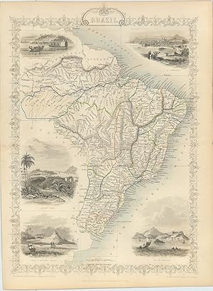
Plantas das Cidades de Rio de Janeiro e Nictheroy. Rio de Janeiro Central Monumental. Titles to Maps: Rio de Janeiro Central Monumental [and] Cidades de Rio de Janeiro e Nictheroy.
Verlag: Aarau SwitzlerandArt. Grav. A. Trüb & Cia. ., 1915
Anbieter: Robert Frew Ltd. ABA ILAB, London, Vereinigtes Königreich
Verbandsmitglied: ABA ILAB PBFA
Verkäuferbewertung 4 von 5 Sternen
Karte
EUR 1.819,07
Währung umrechnenEUR 11,77 für den Versand von Vereinigtes Königreich nach USAAnzahl: 1 verfügbar
In den Warenkorb12mo. (16.5 x 11 cm). pp.42. Publisher's original blue and yellow pictorial cloth. Text in four languages (Portuguese, French, German, and English). Two large colour-printed maps (65 x 84 cm) of Rio de Janeiro, Brazil, printed onto one sheet, the recto showing a detailed map of the central part of the city, the verso with a map of the city and its immediate environs. The map of central Rio features vignettes of the major monuments within the City, along with the waterfront, parks and coastal mountains. The broader map shows Rio, Guanabara Harbor and Niteroi across the Bay in fine detail. Additional full-page engraved map of Rio de Janeiro in the text. One small marginal tear to map not affecting image, generally an excellent copy. OCLC returns just 6 copies, none in the UK.
-

'CARTE DU PARAGUAY ET DES PAYS VOISINS'. Map of Paraguay incl. Uruguay, southern Brazil up to Rio de Janeiro, and northern Chile and Argentina
Verlag: Nicolas Bellin 1756, 1756
Anbieter: Garwood & Voigt, Sevenoaks, Vereinigtes Königreich
Verkäuferbewertung 5 von 5 Sternen
Karte
EUR 48,51
Währung umrechnenEUR 41,21 für den Versand von Vereinigtes Königreich nach USAAnzahl: 1 verfügbar
In den WarenkorbZustand: Fine. 20x31 cm. Large cartouche.
-

'BRASILE'. Miniature map with top and bottom border decoration and view of the city of Rio de Janeiro
Verlag: Italy ca. 1910, 1910
Anbieter: Garwood & Voigt, Sevenoaks, Vereinigtes Königreich
Verkäuferbewertung 5 von 5 Sternen
Karte
EUR 48,51
Währung umrechnenEUR 41,21 für den Versand von Vereinigtes Königreich nach USAAnzahl: 1 verfügbar
In den Warenkorb19 x 11 cm. Chromolithograph. Excellent condition.
-
in zwei Blättern. Entworfen u. gezeichnet von F.v.Stülpnagel Neue berichtigte Auflage. Stahlstiche mit Grenzkolorit mit zwei kleineren Nebenkarten (Bay von Rio de Janeiro; Plan von Rio de Janeiro).
Verlag: Gotha, Justus Perthes, 1860., 1860
Sprache: Deutsch
Anbieter: Antiquariat Heinz Tessin, Quickborn, Deutschland
Verkäuferbewertung 5 von 5 Sternen
Karte
EUR 72,00
Währung umrechnenEUR 4,00 für den Versand von Deutschland nach USAAnzahl: 1 verfügbar
In den Warenkorb32,5 x 63,5 cm. Ränder teils leicht stockfleckig und gebräunt. Zwei Landkarten aus Stieler`s Hand-Atlas No.49b und 49c. Jeweils mit senkrechtem Mittelfalz. [SW - Handatlas, Amerika].
-

"Amér. Mér. / Partie du Bresil. / N° 28" - Brazil Rio de Janeiro Brasilien South America Amerika Südamerika Amerique / from: "Atlas Universel De Geographie, Physique, Politique Et Mineralogique"
Verlag: Bruxelles, 1825
Sprache: Französisch
Anbieter: Antiquariat Steffen Völkel GmbH, Seubersdorf, Deutschland
Verkäuferbewertung 5 von 5 Sternen
Karte Erstausgabe
EUR 149,99
Währung umrechnenEUR 32,00 für den Versand von Deutschland nach USAAnzahl: 1 verfügbar
In den WarenkorbSheet size: ca.54 x72 cm. -- Original handcolored lithographic map from Vandermaelen's folio-size world atlas. It is the first atlas produced by the then new printing process of lithography and the first to show the whole world in maps using a large scale resulting in the most detailed maps at the time. -- partly somewhat browned, otherwise in very good condition. || Original lithographierte, handkolorierte Karte aus Vandermaelen's Weltatlas aus dem Jahre 1827. Es ist der erste Atlas, welcher im damals neuartigen Verfahren der Lithographie hergestellt wurde. -- teils leicht gebräunt, sonst gut erhalten. || Dies ist ein Original! - Kein Nachdruck! - Keine Kopie! -- This is an original! - No copy! - No reprint! Sprache: Französisch Gewicht in Gramm: 35.
-

'BRAZIL'. Map of Brazil with two inset maps of Paraguay and the environs of Rio de Janeiro.
Verlag: Thomas and Cowperthwait in Philadelphia for Mitchell ca. 1850, 1850
Anbieter: Garwood & Voigt, Sevenoaks, Vereinigtes Königreich
Verkäuferbewertung 5 von 5 Sternen
Karte
EUR 72,76
Währung umrechnenEUR 41,21 für den Versand von Vereinigtes Königreich nach USAAnzahl: 1 verfügbar
In den WarenkorbZustand: Fine. 39x31cm. Full original colour. Excellent condition.
-
'AMERIQUE DU SUD'. Map of South America with vignette view of the Bay of Rio de Janeiro.
Verlag: Ch. Lacoste for Migeon ca. 1875, 1875
Anbieter: Garwood & Voigt, Sevenoaks, Vereinigtes Königreich
Verkäuferbewertung 5 von 5 Sternen
Karte
EUR 72,76
Währung umrechnenEUR 41,21 für den Versand von Vereinigtes Königreich nach USAAnzahl: 1 verfügbar
In den WarenkorbZustand: Fine. 42x31cm. Full original colour. Excellent condition.
-

Two panoramic views: 'VIEW OF THE CITY OF RIO DE JANEIRO FROM NICTHEROY ON THE OPPOSITE SIDE OF THE BAY' and above: 'THE SCENE AT RIO DURING THE BOMBARDMENT: VIEW TAKEN FROM SANTA THEREZA IN THE TOWN, 200 FEET ABOVE THE LEVEL OF THE SEA'. Two panoramic views on one double page from a sketch by Mr Philip Swanwick of Rio and Mr. Meisenbach
Verlag: London 1893, 1893
Anbieter: Garwood & Voigt, Sevenoaks, Vereinigtes Königreich
Verkäuferbewertung 5 von 5 Sternen
Karte
EUR 90,95
Währung umrechnenEUR 41,21 für den Versand von Vereinigtes Königreich nach USAAnzahl: 1 verfügbar
In den WarenkorbZustand: Fine. Two uncoloured engravings on one double page. Each view approx 14 x 51 cm.
-

'BRASILIEN UND GUIANA'. Map of Brazil, Suriname and French Guiana. Engraved by E. Biedermann for
Verlag: Joseph Meyer ca. 1850, 1850
Anbieter: Garwood & Voigt, Sevenoaks, Vereinigtes Königreich
Verkäuferbewertung 5 von 5 Sternen
Karte
EUR 90,95
Währung umrechnenEUR 41,21 für den Versand von Vereinigtes Königreich nach USAAnzahl: 1 verfügbar
In den WarenkorbZustand: Fine. 38x31cm. Inset map of the area around Rio de Janeiro. Original outline Colour.
-
'SÜD-AMERICA IN ZWEI BLÄTTERN'. Map of South America, joined from two sheets, with two inset plans of Rio de Janeiro and the Bay of Rio
Verlag: F. v. Stülpnagel for Stielers' Atlas, publ. by Perthes 1843, 1843
Anbieter: Garwood & Voigt, Sevenoaks, Vereinigtes Königreich
Verkäuferbewertung 5 von 5 Sternen
Karte
EUR 109,14
Währung umrechnenEUR 41,21 für den Versand von Vereinigtes Königreich nach USAAnzahl: 1 verfügbar
In den WarenkorbZustand: Fine. 60x36cm. Original outline Colour.
-

in 6 Blättern. Im Maaßstab 1:7500000. Von A.Petermann. Stahlstiche mit Grenzkolorit. Mit 12 kleinen Nebenkarten (Valparaiso und Umgebung, Santiago und Umgebung, Lima, Callao und Umgebung, Die Rhede von La Guiara, Der Hafen von Cartagena de Las Indias, Purto Carello, San Felipe y Santiago de Montevideo und Umgebung, Bahia oder San Salvador ung Umgebung, Santa Marta, Saranilla, Barranquilla und die Mündung des Magdalenen-Stroms, Buenos Aires, Sao Sebastiao de Rio de Janeiro und Umgebung).
Verlag: Gotha, Justus Perthes, 1881., 1881
Sprache: Deutsch
Anbieter: Antiquariat Heinz Tessin, Quickborn, Deutschland
Verkäuferbewertung 5 von 5 Sternen
Karte
EUR 100,00
Währung umrechnenEUR 4,00 für den Versand von Deutschland nach USAAnzahl: 1 verfügbar
In den WarenkorbJe 38,3 x 47,0 cm. 6 Landkarten aus Stieler`s Hand-Atlas No.90 bis 95. Mit senkrechtem Mittelfalz. Die Abbildungen zeigen jeweils nur einen Ausschnitt. [SW - Handatlas].
-
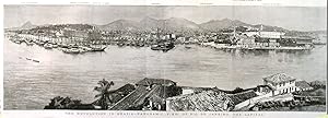
'THE REVOLUTION IN BRAZIL - PANORAMIC VIEW OF RIO DE JANEIRO, THE CAPITAL'. View taken from the sea. Sugar Loaf mountain in the far distance
Verlag: The Graphic 1889, 1889
Anbieter: Garwood & Voigt, Sevenoaks, Vereinigtes Königreich
Verkäuferbewertung 5 von 5 Sternen
Karte
EUR 145,53
Währung umrechnenEUR 41,21 für den Versand von Vereinigtes Königreich nach USAAnzahl: 1 verfügbar
In den WarenkorbZustand: Fine. Uncoloured wood engraving, 19 x 57 cm.
-
'SOUTH AMERICA'. Two maps of South America towards the end of the 19th century, with insets of Rio De Janeiro, Buenos Aires, Valparaiso, Galapagos Islands and Lima
Verlag: Keith Johnston 1892, 1892
Anbieter: Garwood & Voigt, Sevenoaks, Vereinigtes Königreich
Verkäuferbewertung 5 von 5 Sternen
Karte
EUR 145,53
Währung umrechnenEUR 41,21 für den Versand von Vereinigtes Königreich nach USAAnzahl: 1 verfügbar
In den WarenkorbZustand: Fine. Original outline colour. 88 x 57 cm, when joined.
-

South America.
Verlag: London Edinburgh & DublinJ & F Tallis -1856., 1851
Anbieter: Robert Frew Ltd. ABA ILAB, London, Vereinigtes Königreich
Verbandsmitglied: ABA ILAB PBFA
Verkäuferbewertung 4 von 5 Sternen
Karte
EUR 181,91
Währung umrechnenEUR 11,77 für den Versand von Vereinigtes Königreich nach USAAnzahl: 1 verfügbar
In den WarenkorbOriginal steel engraved map. The continent is circled by numerous vignette scenes, including one of Rio de Janeiro. Decorative scrolling and title cartouche around the edges of the image. (Map 22 x 29.5 cm, overall sheet 27.5 x 36 cm). Original outline colour. Centrefold crease as issued. With additional later hand colouring to border and vignettes. For the Great Exhibition in 1851 John Tallis (1817-1876) worked with engraver John Rapkin (1815-1876) to publish the 'Illustrated World Atlas', whose maps were later re-issued by the London Printing and Publishing Company. Their maps are prized for their wonderful steel-engraved vignettes showing the peoples, customs, architecture, landmarks, flora, and fauna of each country.
-

South America.
Verlag: London & New YorkJ & F Tallis -1856., 1851
Anbieter: Robert Frew Ltd. ABA ILAB, London, Vereinigtes Königreich
Verbandsmitglied: ABA ILAB PBFA
Verkäuferbewertung 4 von 5 Sternen
Karte
EUR 181,91
Währung umrechnenEUR 11,77 für den Versand von Vereinigtes Königreich nach USAAnzahl: 1 verfügbar
In den WarenkorbOriginal steel engraved map. The continent is circled by numerous vignette scenes, including one of Rio de Janeiro. Decorative scrolling and title cartouche around the edges of the image. (Map 29.5 x 22 cm, overall sheet 36 x 27.5 cm). Original outline colour with additional later hand colouring to border and vignettes. Centrefold crease as issued. For the Great Exhibition in 1851 John Tallis (1817-1876) worked with engraver John Rapkin (1815-1876) to publish the 'Illustrated World Atlas', whose maps were later re-issued by the London Printing and Publishing Company. Their maps are prized for their wonderful steel-engraved vignettes showing the peoples, customs, architecture, landmarks, flora, and fauna of each country.
-

Brazil.
Verlag: London & New YorkJohn Tallis & Company -1856., 1851
Anbieter: Robert Frew Ltd. ABA ILAB, London, Vereinigtes Königreich
Verbandsmitglied: ABA ILAB PBFA
Verkäuferbewertung 4 von 5 Sternen
Karte
EUR 242,54
Währung umrechnenEUR 11,77 für den Versand von Vereinigtes Königreich nach USAAnzahl: 1 verfügbar
In den WarenkorbOriginal steel engraved map of Brazil (36 x 27.5 m) With five vignette illustrations, including views of Rio De Janeiro and Montevideo. Decorative scrolling and title cartouche around the edges of the maps. Also includes Uruguay. Original outline colour, with additional later hand colour to vignettes and borde, and to the body of the map. An excellent example. For the Great Exhibition in 1851 John Tallis (1817-1876) worked with engraver John Rapkin (1815-1876) to publish the 'Illustrated World Atlas', whose maps were later re-issued by the London Printing and Publishing Company. Their maps are prized for their steel-engraved vignettes showing the peoples, customs, architecture, landmarks, flora, and fauna of each country.
-
Brazil.
Verlag: London & New YorkJohn Tallis & Company -1856., 1851
Anbieter: Robert Frew Ltd. ABA ILAB, London, Vereinigtes Königreich
Verbandsmitglied: ABA ILAB PBFA
Verkäuferbewertung 4 von 5 Sternen
Karte
EUR 242,54
Währung umrechnenEUR 11,77 für den Versand von Vereinigtes Königreich nach USAAnzahl: 1 verfügbar
In den WarenkorbOriginal steel engraved map of Brazil (27.5 x 36 cm) with original outline colour. With five vignette illustrations, including views of Rio De Janeiro and Montevideo. Decorative scrolling and title cartouche around the edges of the maps. Also includes Uruguay. Original outline colour. Centrefold crease as issued Generally an excellent example. For the Great Exhibition in 1851 John Tallis (1817-1876) worked with engraver John Rapkin (1815-1876) to publish the 'Illustrated World Atlas', whose maps were later re-issued by the London Printing and Publishing Company. Their maps are prized for their steel-engraved vignettes showing the peoples, customs, architecture, landmarks, flora, and fauna of each country.
-
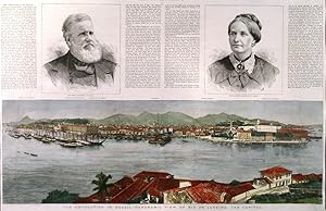
'THE REVOLUTION IN BRAZIL - PANORAMIC VIEW OF RIO DE JANEIRO, THE CAPITAL'. View taken from across the bay. Sugar Loaf mountain in the far distance. Above text about the revolution and two portraits of Dom Pedro, Ex-Emperor of Brazil, and his wife Donna Theresa. Separately published in London as a supplement to
Verlag: The Graphic 1889, 1889
Anbieter: Garwood & Voigt, Sevenoaks, Vereinigtes Königreich
Verkäuferbewertung 5 von 5 Sternen
Karte
EUR 212,23
Währung umrechnenEUR 41,21 für den Versand von Vereinigtes Königreich nach USAAnzahl: 1 verfügbar
In den WarenkorbZustand: Fine. 36 x 57 cm. The panorama (19x57cm) in full recent colour. Excellent condition.


![Bild des Verkäufers für Süd-America in zwei Blättern [und] Der südliche Theil von Südamerika. - [Zwei kolorierte Karten aus dem Handatlas von Stieler]. zum Verkauf von ANTIQUARIAT Franke BRUDDENBOOKS](https://pictures.abebooks.com/inventory/md/md31724716700.jpg)
![Bild des Verkäufers für Plantas das Cidades de Rio de Janeiro e Nictheroy. Rio de Janeiro Central Monumental. Titles to Maps: Rio de Janeiro Central Monumental [and] Cidades de Rio de Janeiro e Nictheroy. zum Verkauf von Robert Frew Ltd. ABA ILAB](https://pictures.abebooks.com/inventory/md/md31717185880.jpg)

