
Gesamtpreis (1 Artikel Artikel):
Versandziel:

das osmanische reich: Karten (8 Ergebnisse)
Feedback
Direkt zu den wichtigsten Suchergebnissen
Suchfilter
Produktart
- Alle Product Types
- B³cher (272)
- Magazine & Zeitschriften (1)
- Comics (Keine weiteren Ergebnisse entsprechen dieser Verfeinerung)
- Noten (Keine weiteren Ergebnisse entsprechen dieser Verfeinerung)
- Kunst, Grafik & Poster (8)
- Fotografien (Keine weiteren Ergebnisse entsprechen dieser Verfeinerung)
- Karten (8)
- Manuskripte & Papierantiquitõten (Keine weiteren Ergebnisse entsprechen dieser Verfeinerung)
Zustand
- Alle
- Neu (Keine weiteren Ergebnisse entsprechen dieser Verfeinerung)
- Antiquarisch (8)
Einband
- alle Einbõnde
- Hardcover (Keine weiteren Ergebnisse entsprechen dieser Verfeinerung)
- Softcover (Keine weiteren Ergebnisse entsprechen dieser Verfeinerung)
Weitere Eigenschaften
- Erstausgabe (1)
- Signiert (Keine weiteren Ergebnisse entsprechen dieser Verfeinerung)
- Schutzumschlag (Keine weiteren Ergebnisse entsprechen dieser Verfeinerung)
- Angebotsfoto (7)
Sprache (2)
Gratisversand
- Kostenloser Versand nach USA (Keine weiteren Ergebnisse entsprechen dieser Verfeinerung)
Land des Verkõufers
Verkõuferbewertung
-

Das Osmanische Reich in Asien (Klein-Asien, Armenien, Kurdestan, Mesopotamien, Syrien). Entw. u .gez. von F.von St³lpnagel. Gestochen von C.Poppey. Stahlstich mit Grenzkolorit und einer kleinen Nebenkarte (Vereinigung des Euphrat u. Tigris im Schatt-el-Arab).
Verlag: Gotha, Justus Perthes, 1860., 1860
Sprache: Deutsch
Anbieter: Antiquariat Heinz Tessin, Quickborn, Deutschland
Verkõuferbewertung 5 von 5 Sternen

Karte
EUR 48,00
Wõhrung umrechnenEUR 4,00 f³r den Versand von Deutschland nach USAAnzahl: 1 verf³gbar
In den Warenkorb32,0 x 42,0 cm. Landkarte aus Stieler`s Hand-Atlas No.43a. Mit senkrechtem Mittelfalz. [SW - Handatlas, Asien].
-
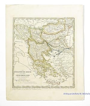
Das Osmanische Reich in Europa, Griechenland und die Ionischen Inseln. Blatt No. XVIIb aus: Stieler's Schul-Atlas. Von Hand grenzkolorierter Kupferstich.
Verlag: Perthes, Gotha, 1854
Sprache: Deutsch
Anbieter: Magister Michalis, Internet-Antiquariat, Wielenbach, Deutschland
Verkõuferbewertung 5 von 5 Sternen
Karte
EUR 15,21
Wõhrung umrechnenEUR 50,99 f³r den Versand von Deutschland nach USAAnzahl: 1 verf³gbar
In den WarenkorbKein Einband. Zustand: Sehr gut. Blattgr÷▀e ca. 29x23,5 cm. Vierfarbig von Hand grenzkolorierte Karte. Hell geblieben u. fast fleckenlos. Original-Kolorierung sofort nach Druck, ohne spõtere Nachzeichnungen oder Verschlimmbesserungen, Farben noch klar und leuchtend. Minimale Stockflecken am õu▀eren wei▀en unbedruckten Rand. +++ COPPER ENGRAVING WITH HAND COLORING in outline when published.+++ Aus Nichtraucherhaushalt. +++ Mehr Infos gerne ³ber die Schaltflõche 'Frage an den Anbieter'.
-

Das Osmanische Reich in Europa Nach den Neuesten Geographischen Ortsbestimmungen und Besten Karten Entworfen
Verlag: Johann Walch c.1822, Augsburg, 1822
Anbieter: Alexandre Antique Prints, Maps & Books, Toronto, ON, Kanada
Verkõuferbewertung 2 von 5 Sternen

Karte
EUR 339,64
Wõhrung umrechnenEUR 5,28 f³r den Versand von Kanada nach USAAnzahl: 1 verf³gbar
In den WarenkorbZustand: Very Good. This map detailing the Ottoman Empire and it's territories in Europe during the early 19th century. The map shows borders, geographical details, and the names of cities and towns. There is an inset map of Crete on the lower left side of the map. Johann Walch (1757-1824) was cartographer and map publisher active in Augsburg, he was the son-in-law of Johann Martin Will whom he succeeded in 1806., Size : 495x583 (mm), 19.49x22.95 (Inches), Original Hand Coloring.
-

Das Osmanische Reich in Europa mit einem Theile desselben in Asien nebst den Angrõnzenden oesterreichischen und russischen Gebieten in dem Stande vom Jahre 1828. Bearbeitet in VI Blõttern nach den besten Quellen in der J. G. Cotta schen geographischen Anstalt in M³nchen.
Verlag: J. G. Cotta schen geographischen Anstalt, M³nchen, 1828
Anbieter: Antiquariat Reinhold Berg eK Inh. R.Berg, Regensburg, Deutschland
Verkõuferbewertung 5 von 5 Sternen
Karte
EUR 1.200,00
Wõhrung umrechnenEUR 24,00 f³r den Versand von Deutschland nach USAAnzahl: 1 verf³gbar
In den WarenkorbOther. Original lithographed map, uncolored. Engraved by W. Pobuda. The large map shows the region between Kolomyja in the north to Rhodes in the south. In the lower left corner is an inset with the island Crete. Overall in very good to excellent condition. 1400 by 1180mm (55 by 46Į inches).
-

Kupferstich- Karte, v. anonym, "Das Osmanische Reich".
Sprache: Deutsch
Anbieter: Antiquariat Clemens Paulusch GmbH, Berlin, Deutschland
Verkõuferbewertung 5 von 5 Sternen
Karte
EUR 50,00
Wõhrung umrechnenEUR 26,90 f³r den Versand von Deutschland nach USAAnzahl: 1 verf³gbar
In den Warenkorb1839, 17,5 x 22.
-

Das Osmanische Reich
Verlag: Bibliographisches Institut, 1849
Sprache: Deutsch
Anbieter: historicArt Antiquariat & Kunsthandlung, Wiesbaden-Breckenheim, Deutschland
Verkõuferbewertung 4 von 5 Sternen

Karte Erstausgabe
EUR 94,00
Wõhrung umrechnenEUR 12,00 f³r den Versand von Deutschland nach USAAnzahl: 1 verf³gbar
In den Warenkorb1. alte Landkarte, gestochen von K. L. von Baehr, 23 x 28 cm (H÷he x Breite) auf r³ckseitig unbedrucktem B³ttenblatt, sch÷nes und wohlerhaltenes Exemplar 2100 gr.
-

Kupferstich- Karte, anonym, "Das Osmanische Reich in Europa. Nach den neuesten geographischen Ortsbestimmungen und besten Karten entworfen. - L' empire Ottoman en Europe .".
Sprache: Deutsch
Anbieter: Antiquariat Clemens Paulusch GmbH, Berlin, Deutschland
Verkõuferbewertung 5 von 5 Sternen
Karte
EUR 300,00
Wõhrung umrechnenEUR 26,90 f³r den Versand von Deutschland nach USAAnzahl: 1 verf³gbar
In den Warenkorbmit altem Grenzkolorit, um 1800, 49 x 58 Seltene Karte. Nicht in Zacharakis. ▄ber der Karte Kopftitel in deutscher und franz. Sprache., unten links kleine Insetkarte von Kreta.
-
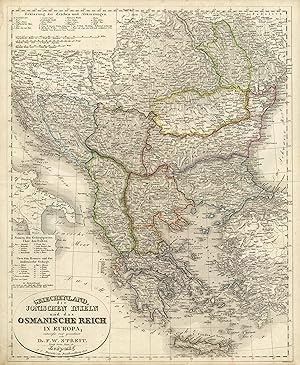
'Griechenland, die Jonischen Inseln und das Osmanische Reich in Europa; entworfen und gezeichnet von Dr. F.W. Streit K÷nigl. Preuss. Major a.D. - Leipzig, J.C. Hinrichs'sche Buchhandlung 1834. - H. Leutemann sc.':.
Sprache: Deutsch
Anbieter: Antiquariat Norbert Haas, Bedburg-Hau, Deutschland
Verkõuferbewertung 5 von 5 Sternen
Karte
EUR 350,00
Wõhrung umrechnenEUR 40,00 f³r den Versand von Deutschland nach USAAnzahl: 1 verf³gbar
In den WarenkorbAltkolorierte Lithographie v. H. Leutemann n. Friedrich Wilhelm Streit b. J.C. Hinrichs in Leipzig, dat. 1835, 48 x 39 Tooley's Dic. of Mapm. Rev. Ed. K - P, S. 126 (Heinrich Leutemann. Engraver of Leipzig. .). - Zeigt das Gebiet von Ungarn bis Kreta und Adria bis zum Schwarzen Meer. - Unten links Titelkartusche und Erklõrungen. - Oben links weitere Erklõrungen.
