Gesamtpreis (1 Artikel Artikel):
Versandziel:

das schwarze meer: Karten (9 Ergebnisse)
Feedback
Direkt zu den wichtigsten Suchergebnissen
Suchfilter
Produktart
- Alle Product Types
- B■cher (120)
- Magazine & Zeitschriften (1)
- Comics (Keine weiteren Ergebnisse entsprechen dieser Verfeinerung)
- Noten (Keine weiteren Ergebnisse entsprechen dieser Verfeinerung)
- Kunst, Grafik & Poster (9)
- Fotografien (Keine weiteren Ergebnisse entsprechen dieser Verfeinerung)
- Karten (9)
- Manuskripte & Papierantiquitðten (1)
Zustand
- Alle
- Neu (Keine weiteren Ergebnisse entsprechen dieser Verfeinerung)
- Antiquarisch (9)
Einband
- alle Einbðnde
- Hardcover (Keine weiteren Ergebnisse entsprechen dieser Verfeinerung)
- Softcover (Keine weiteren Ergebnisse entsprechen dieser Verfeinerung)
Weitere Eigenschaften
- Erstausgabe (1)
- Signiert (1)
- Schutzumschlag (Keine weiteren Ergebnisse entsprechen dieser Verfeinerung)
- Angebotsfoto (8)
Sprache (4)
Preis
- Beliebiger Preis
- Weniger als EUR 20 (Keine weiteren Ergebnisse entsprechen dieser Verfeinerung)
- EUR 20 bis EUR 45
- Mehr als EUR 45
Gratisversand
- Kostenloser Versand nach USA (Keine weiteren Ergebnisse entsprechen dieser Verfeinerung)
Land des Verkðufers
Verkðuferbewertung
-

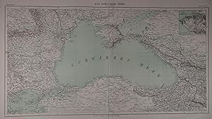
Das Mittellðndische und Schwarze Meer, nebst Ébersicht der Lðnder des Osmanischen Reichs. Bearbeitet von F.v.St■lpnagel und Herm.Berghaus. Stahlstich mit Grenzkolorit, unten mit 5 Nebenkarten (Madeira und die Canarischen Inseln; Meerenge der Dardanellen; Meerenge von Constantinopel, Constantinopel; Alexandria).
Verlag: Gotha, Justus Perthes, 1860., 1860
Sprache: Deutsch
Anbieter: Antiquariat Heinz Tessin, Quickborn, Deutschland
Verkðuferbewertung 5 von 5 Sternen

Karte
EUR 43,00
Wðhrung umrechnenEUR 4,00 f■r den Versand von Deutschland nach USAAnzahl: 1 verf■gbar
In den Warenkorb31,5 x 41,5 cm. Landkarte aus Stieler`s Hand-Atlas No.42a. Mit senkrechtem Mittelfalz. [SW - Handatlas, Atlanischer Ozean].
-
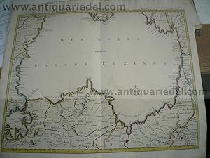
Das Schwarze Meer. Grenzkolorierte, lithographierte Karte in zwei Farben in 2 Blatt (mit Leinenstreifen zusammengesetzt) entworfen von F. Handtke aus "Vollstðndiger Universal-Handatlas". Glogau, Carl Flemming ca 1850, 36 x 67 cm
Anbieter: Antiquariat Johannes M■ller, Salzburg, østerreich
Verkðuferbewertung 5 von 5 Sternen
Karte
Rechts oben Insetkarte "Hðfen von Sewastopol".-# Lithographed map of Black Sea. Printed on two sheets with original outline colour, joined together with a linen strip.-.
-

Landkarte "Das schwarze Meer" aus K. Sohr: Vollstðndiger Universal-Handatlas der neueren Erdbeschreibung
Verlag: Glogau, Flemming, 1848, 1848
Sprache: Deutsch
Anbieter: AMAHOFF- Bookstores, RoÔtal, Deutschland
Verkðuferbewertung 3 von 5 Sternen

Karte
EUR 29,90
Wðhrung umrechnenEUR 45,00 f■r den Versand von Deutschland nach USAAnzahl: 1 verf■gbar
In den WarenkorbZustand: Gut. Grenzkol. Lithographie, C. Flemming, Glogau, 1848. - Aus: "Vollstðndiger Universal=Handatlas der neueren Erdbeschreibung". - Mit Angabe der politischen Einteilung und Zeichenerklðrung. Blattgr—Ôe: ca. 45 x 67cm Querformat. Gebrauchsspuren und Flecken, insgesamt altersgemðÔ guter Zustand. siehe auch Foto oben Sprache: Deutsch Gewicht in Gramm: 550.
-
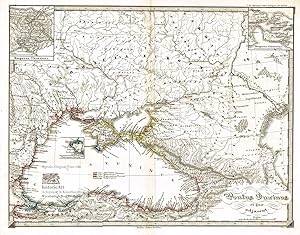
"Kriegstheater oder Graenzkarte Oesterreichs, Russlands, und der T■rkey, enthalten Das K—nigrecih Ungarn, Siebenb■rgen, Moldau, Bessarabien, Walachey, Bulgarien, Servien, Bosnien, Sclavonien, Croatien, Albanien, Romanien, Maceodnien, einen Theil Griechenlands, und des Archipelagus, die Dardanellen, die Schwarze und asowische Meer." - Black Sea Ukraine Russia Bulgaria Romania / Schwarzes Meer Russland Bulgarien Rumðnien
Verlag: Wien, Artaria, 1788
Sprache: Franz—sisch
Anbieter: Antiquariat Steffen V—lkel GmbH, Seubersdorf, Deutschland
Verkðuferbewertung 5 von 5 Sternen
Karte
EUR 219,99
Wðhrung umrechnenEUR 32,00 f■r den Versand von Deutschland nach USAAnzahl: 1 verf■gbar
In den WarenkorbAltkolorierte Kupferstich-Kartevon 1788. - Blattmasse: ca. 52 x 74 cm. -- etwas fleckig, mit Knickspuren, sonst gut erhalten. || Old colored engraved map from 1788. -- with some staining, with fold marks, otherwise in good condition. Sprache: Franz—sisch Gewicht in Gramm: 35.
-

'DAS SCHWARZE MEER NEBST KRIEGSSCHAUPLATZ IN DER EUROPAISCH U ASIATISCH TURKEI'. The Black Sea and it's shores. Inset of Sebastopol.
Verlag: C.Flemming ca 1850, 1850
Anbieter: Garwood & Voigt, Sevenoaks, Vereinigtes K—nigreich
Verkðuferbewertung 5 von 5 Sternen
Karte
EUR 72,40
Wðhrung umrechnenEUR 41,00 f■r den Versand von Vereinigtes K—nigreich nach USAAnzahl: 1 verf■gbar
In den WarenkorbZustand: Fine. Outline coloured steel engraving in two parts. Could be joined to form one map, 36 x 67 cm.
-
Pontus Euxinus et quae adjacent. Das Schwarze Meer mit allen Anrainer-Staaten und K■stenstðdten. GroÔe Landkarte mit zwei Innenkarten "Bosporus Thracicus" und "Bosporus Cimmerius". Grenzkolorierter Kupferstich von Carl Stier aus Spruners "Atlas antiquus", 1847
Verlag: Gotha: Justus Perthes, 1847
Sprache: Latein
Anbieter: historicArt Antiquariat & Kunsthandlung, Wiesbaden-Breckenheim, Deutschland
Verkðuferbewertung 4 von 5 Sternen

Karte Erstausgabe Signiert
EUR 90,00
Wðhrung umrechnenEUR 12,00 f■r den Versand von Deutschland nach USAAnzahl: 2 verf■gbar
In den Warenkorb1. Original-Kupferstich von Carl Stier (in der Platte signiert) auf r■ckseitig unbedrucktem B■ttenblatt mit dekorativ abgesetztem Plattenrand, Imperialfolio-Doppelblatt, von alter Hand gewissenhaft grenzkoloriert und die gr—Ôeren Stðdte farbig unterstrichen, bildliche Darstellung ca. 30,5 x 40 cm, Blattgr—Ôe ca. 35 x 45 cm (jeweils H—he x Breite), geglðttete Mittelfalz, in der linken oberen Blattecke auÔerhalb der bildlichen Darstellung etwas wasserrandig, ansonsten sauber und sehr gut erhalten 2100 gr.
-
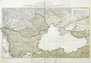
SECONDE PARTIE DE LA CRIMèE, LA MER NOIRE &C. RECTIFIèS PAR DIVERSES OBSERVATIONS, FAITES PAR GUILLAUME DE L'ISLE. A AMSTERDAM, CHEZ JEAN COVENS ET CORNEILLE MORTIER, GèOGRAPHES. Altkolorierte Karte zeigt das Schwarze Meer. A scarce and attractive map embracing most of the Black Sea, one of the finest maps of the region made during the first half of the 18th Century, issued by the leading Amsterdam firm of Covens & Mortier. Author: Johannes COVENS & Cornelis MORTIER. Place and Year: Amsterdam, 1742. Technique: Copper engraving with original outline colour (Very Good, a strong and clean example), 49 x 61 cm (19 x 24 inches). Grenzkolorierter Kupferstich. Gut erhalten. This fine map features most of the Black Sea, which occupies the hea
Verlag: Amsterdam, 1742
Anbieter: Hammelburger Antiquariat, Hammelburg, Deutschland
Verkðuferbewertung 4 von 5 Sternen
Karte
EUR 500,00
Wðhrung umrechnenEUR 30,00 f■r den Versand von Deutschland nach USAAnzahl: 1 verf■gbar
In den WarenkorbKein Einband. Zustand: Befriedigend. SECONDE PARTIE DE LA CRIMèE, LA MER NOIRE &C. RECTIFIèS PAR DIVERSES OBSERVATIONS, FAITES PAR GUILLAUME DE L'ISLE. A AMSTERDAM, CHEZ JEAN COVENS ET CORNEILLE MORTIER, GèOGRAPHES. Altkolorierte Karte zeigt das Schwarze Meer. A scarce and attractive map embracing most of the Black Sea, one of the finest maps of the region made during the first half of the 18th Century, issued by the leading Amsterdam firm of Covens & Mortier. Author: Johannes COVENS & Cornelis MORTIER. Place and Year: Amsterdam, 1742. Technique: Copper engraving with original outline colour (Very Good, a strong and clean example), 49 x 61 cm (19 x 24 inches). Grenzkolorierter Kupferstich. Gut erhalten. This fine map features most of the Black Sea, which occupies the heart of the map. It captures the southern part of the Crimean Peninsula and, working clockwise, takes in the coasts of modern day Georgia; Anatolia (Turkey), including the famous trading centre of Trebizond; Istanbul and much of the Sea of Marmara; as well as the coasts of modern day Bulgaria and Romania. All major towns and landmarks are carefully represented in the attractive, clear style of engraving that was a hallmark of the Covens & Mortier firm. During the era that this map was made, the Black Sea was considered to be a virtual "Turkish Lake," with the Ottoman Empire controlling virtually all of its shores. That being said, the Russian Empire was beginning to challenge Ottoman hegemony over its northern shores, although it would not be until the 1770s that she would consolidate enduring territorial gains. The innumerable Russo-Turkish conflicts kept the region at the top of the news in Europe for most of the 18th Century. Geographically, while the region as presented on the map is vaguely familiar to the modern viewer, its is not mapped with especially great accuracy, owing to the fact that Western Europeans seldom had the opportunity to reconnoitre the Black Sea. Indeed significant progress on the scientific mapping of the region would not be made until Captain Jan Hendrik van Kinsbergen, a Dutchman in Russian service, conducted the first proper mapping of the Crimea in 1773. The present map was published by Covens & Mortier within their atlas Atlas Nouveau, contenant toutes les parties su Monde, ou sont exactement remarquees les empires, monarchies, royaumes, etats, republiques, &c.(Amsterdam, 1742). While the map is complete, in an of itself, it can be paired with the map Theatre de la Guerre Dans la Petite Tartarie, La Crimee, la Mer Noire, &c., which focuses on the Ukraine, to the north. Both maps are based on Guillaume De l'Isle's 1720 maps of the region. The Firm of Covens & Mortier The present map was issued by the eminent map publishing firm of Covens & Mortier, which existed in various forms from 1690 to 1866. At the time that this map was issued, it was owned and operated by Johannes Covens I (1697 - 1774) and Cornelis Mortier (1699 - 1783). During much of the 18th Century, the enterprise was the Netherlands' leading cartography establishment. The firm had its roots with Pierre Mortier (1661-1711), one of the most commercially successful map publishers of his time, who opened his own cartography enterprise in 1690. Operating in Amsterdam, Mortier benefitted from the Dutch Republic's highly developed print market and liberal censorship laws. Mortier formed a partnership with his brother David, but maintained a dominant role in the relationship. Following Pierre Mortier's death in 1711, his firm was maintained for a decade by his heirs. In 1721, the firm was rolled into the partnership of Johannes Covens and Cornelis Mortier. From its headquarters at the Vijgendam in Amsterdam, the firm issued numerous full feature atlases and separately-issued maps predicated on the latest sources, including those relating to current events such as the Ottoman-European Wars, including the Black Sea region. References: A. Gordyeyev & V. Bulatov, Cartography of the Black Sea and the Sea of Azov: Retro.
-

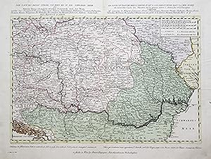
'Der Lauf Des Donau Stroms Von Wien Bis In Das Schwarze Meer oder Neuester Kriegsschauplatz zwischen Oesterreich un der Pforte welcher das Koenigreich Ungarn, Sclavonien, Sirmien, Siebenb■rgen, Bukowina, Croatien, Dalmatien, Bosnien, Servien, Bulgarien, die Walachei, Bessarabien, die Ukraine, Galizien, Maehren, Oesterreich, und Steyermark, &. enhðlt. - Le Cours Du Danube Depuis Vienne Jusqu' A Son Embouchure Dans La Mer Noire ou nouvelle Carte du Theatre de la guerre entre l'Austriche et la Turquie Contenant Le royaume de Hongrie, Esclavonie, Sirmie, Transylvanie, Bukovine, Croatie, Dalmatie, Bosnie, Servie, Valachie, Moldavie, Bessarabie, l'Ukraine, avec une partie de la Galicie, Moravie, Austriche, Stirie. &. &. - Nach den besten Karten und Handzeichnungen entworfen und gestochen von F. M■ller.':.
Sprache: Deutsch
Anbieter: Antiquariat Norbert Haas, Bedburg-Hau, Deutschland
Verkðuferbewertung 5 von 5 Sternen
Karte
EUR 1.500,00
Wðhrung umrechnenEUR 40,00 f■r den Versand von Deutschland nach USAAnzahl: 1 verf■gbar
In den WarenkorbAltkolorierter Kupferstich v. Franz M■ller b. Artaria Compagnie in Wien, 1788, 40 x 51,5 SzÃntai, Atlas Hungaricus 1528-1850, Vol. I, S. 22, Artaria 2; nicht bei Wolf - Zimmermann, Karten des Donauraums 1650-1800. - Zeigt den Donaulauf zwischen dem Schwarzen Meer und Krems a.d. Donau sowie das Gebiet zwischen Lemberg (Lwiw) in der Ukraine und Nis (Nissa) in Serbien. - Mittig Siebenb■rgen. - Die Karte mit Titelkopfleiste. - Oben rechts Kartusche mit Erklðrungen und Angaben zu den Postwegen. - Unter der Karte Erklðrungen zum Kolorit. - Seltener Einblattdruck in einem perfektem Zustand!
-
Kupferstich- Karte, n. v. Fr. M■ller bei Artaria in Wien, "Der Lauf des Donau Stroms von Wien bis in das Schwarze Meer oder Neuester Kriegsschauplatz zwischen Osterreich und der Pforte, welcher das Koenigreich UnGesamtansichtrn, Sclavonien, Sirnien, Siebenb■rgen, Bujowina, Croatien, Dalmatien. Bosnien, Servien, BulGesamtansichtrien, die Walachei, Bessarabien, die Ukraine, Gesamtansichtlizien, Mðhren, Oesterreich, und Steyermark, & enthðlt. - Le Cours du Danube .".
Sprache: Deutsch
Anbieter: Antiquariat Clemens Paulusch GmbH, Berlin, Deutschland
Verkðuferbewertung 5 von 5 Sternen
Karte
EUR 750,00
Wðhrung umrechnenEUR 26,90 f■r den Versand von Deutschland nach USAAnzahl: 1 verf■gbar
In den Warenkorbmit altem Flðchenkolorit, 1788, 33,5 x 51 D—rflinger, Art. 7; Szantai, Atlas Hungaricus, Artaria 2. - Seltener Einblattdruck und zugleich eine der fr■hestens von Artaria herausgegebenen Karten, zeigt den Donaulauf zwischen Wien und der M■ndung, im S■dwesten die Adria. Éber der Karte Kopftitel in deutscher und franz. Sprache, unter der Karte Erklðrungen zu den Farben ("Roth ist osterreichisch" usw.). Ausgezeichnetes Exemplar.