
Gesamtpreis (1 Artikel Artikel):
Versandziel:

germania von mercator (7 Ergebnisse)
Feedback
Direkt zu den wichtigsten Suchergebnissen
Suchfilter
Produktart
- Alle Product Types
- Bücher (3)
- Magazine & Zeitschriften (Keine weiteren Ergebnisse entsprechen dieser Verfeinerung)
- Comics (Keine weiteren Ergebnisse entsprechen dieser Verfeinerung)
- Noten (Keine weiteren Ergebnisse entsprechen dieser Verfeinerung)
- Kunst, Grafik & Poster (Keine weiteren Ergebnisse entsprechen dieser Verfeinerung)
- Fotografien (Keine weiteren Ergebnisse entsprechen dieser Verfeinerung)
- Karten (4)
- Manuskripte & Papierantiquitäten (Keine weiteren Ergebnisse entsprechen dieser Verfeinerung)
Zustand
- Alle
- Neu (Keine weiteren Ergebnisse entsprechen dieser Verfeinerung)
- Antiquarisch (7)
Einband
- alle Einbände
- Hardcover (Keine weiteren Ergebnisse entsprechen dieser Verfeinerung)
- Softcover (Keine weiteren Ergebnisse entsprechen dieser Verfeinerung)
Weitere Eigenschaften
- Erstausgabe (Keine weiteren Ergebnisse entsprechen dieser Verfeinerung)
- Signiert (1)
- Schutzumschlag (Keine weiteren Ergebnisse entsprechen dieser Verfeinerung)
- Angebotsfoto (5)
Sprache (1)
Gratisversand
- Kostenloser Versand nach USA (Keine weiteren Ergebnisse entsprechen dieser Verfeinerung)
Land des Verkäufers
Verkäuferbewertung
-

Germania.
Erscheinungsdatum: 1990
Anbieter: Antiquariat Diderot, Kiel, SH, Deutschland
Verkäuferbewertung 5 von 5 Sternen

EUR 20,00
Währung umrechnenEUR 19,50 für den Versand von Deutschland nach USAAnzahl: 1 verfügbar
In den WarenkorbPhotomechanischer Faksimile-Nachdruck einer kolorierten Kupferstichkarte von Mercator, um 1600. Faksmile ca. von 1990. Balttgröße 44 x 63 cm.- Mittig gefaltet, verso hälftig lateinischer Text. Graphik und Bilder, Karten, Landkarten, Deutschland, Faksimiles.
-
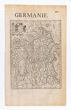
Germania. / Germanie.
Verlag: Londonprinted by T.Cotes for Michael Sparkes and Samuel Cartwright., 1635
Anbieter: Robert Frew Ltd. ABA ILAB, London, Vereinigtes Königreich
Verbandsmitglied: ABA ILAB PBFA
Verkäuferbewertung 4 von 5 Sternen

Karte
EUR 54,17
Währung umrechnenEUR 11,69 für den Versand von Vereinigtes Königreich nach USAAnzahl: 1 verfügbar
In den Warenkorb14.5 x 19.5 cm. Uncoloured. Single page general map of Germany. English text on verso. Generally good condition. From "Historia Mundi or Mercator's Atlas .".
-

Germania
Verlag: Hondius, Jodocus, 1609
Anbieter: Antikvariat Krenek, Prag, Tschechien
Verbandsmitglied: ILAB
Verkäuferbewertung 5 von 5 Sternen
Karte
EUR 62,51
Währung umrechnenEUR 14,50 für den Versand von Tschechien nach USAAnzahl: 1 verfügbar
In den WarenkorbKein Einband. Zustand: Sehr gut. Mitteleuropa. "Germania". Orig. copperplate engraving from Mercator's Atlas Minor. Published by J. Hondius in Amsterdam, 1609. With ornamental title cartouche and title above the map ('La Germanie'). 15:19,5 cm on paper sized 17,5:22 cm. Koeman III, map 2000:351, ed. 351:11 (1609 Atlas Minor [Fr.]). - A miniature map of Central Europe.
-

GERMANIA.
Verlag: Atlas Minor. Jan Jansson. 1651, 2nd German edition., 1651
Anbieter: Peter Harrington. ABA/ ILAB., London, Vereinigtes Königreich
Verbandsmitglied: ABA ILAB PBFA
Verkäuferbewertung 5 von 5 Sternen
EUR 144,47
Währung umrechnenEUR 16,36 für den Versand von Vereinigtes Königreich nach USAAnzahl: 1 verfügbar
In den WarenkorbBeautiful map of Germany from Jansson's edition of Mercator's Atlas Minor. Moreland & Bannister, Antique Maps, p.98. Copper engraving. Fine condition. Original colour. Size: 19 x 14 cm. (7˝ x 5˝ inches).
-

Germania
Verlag: I.E. Cloppenburgh, Amsterdam, 1632
Anbieter: Antiquariat Reinhold Berg eK Inh. R.Berg, Regensburg, Deutschland
Verkäuferbewertung 5 von 5 Sternen
Karte Signiert
EUR 145,00
Währung umrechnenEUR 24,00 für den Versand von Deutschland nach USAAnzahl: 1 verfügbar
In den WarenkorbOther. Original antique copper engraving, uncolored as published. A fine copy in a dark impression, full margins as published. The map shows the area from Bornholm in the north to Trento in the south, from Dover in the west to Karas/Hungaria in the east. This is the first so-called Cloppenburgh editions which was a competive edition with new engraved maps in a larger format. Most of the maps were engraved by Pieter van den Keere. The Cloppenburgh edition was continued for a couple of years but seems to have been suppressed after 1636. This is another Cloppenburgh edition, now with Latin text. The maps from the Appendix have been incorporated. The title-page is followed by a dedication to Prince Frederik Hendrik, dated 1632 and signed by Johannes Cloppenburgh. (Koeman Atlantes Neerlandici). In excellent condition. 183 by 250mm (7 by 9 inches).
-

Germania
Verlag: Amsterdam, 1630
Anbieter: Libreria Ex Libris ALAI-ILAB/LILA member, Roma, Italien
Verkäuferbewertung 4 von 5 Sternen
Karte
EUR 150,00
Währung umrechnenEUR 30,00 für den Versand von Italien nach USAAnzahl: 1 verfügbar
In den WarenkorbCarta geografica (cm. 25,5x18,5) tratta dall' 'Atlas sive Cosmographicae Meditationes de Fabrica Mundi et fabricati figura.' edito da Jan Cloppenburgh. Leggera brunitura della carta. Mancante il margine sinistro.
-
Atlas sive cosmographicae meditationes de fabrica mundi et fabricati figura. Faksimile der Ausgabe Duisburg 1595. Stgt., Coron 1980. Folio. 57 farb. doppelblattgroße Karten. Dunkelbrauner Originallederband mit Goldprägung. (leicht berieben).- Vorliegende Ausgabe enthält die Weltkarte, sowie sämtliche Kontinentalkarten. Die europäischen Länder sind mit den jeweiligen Generalkarten vertreten, die Schweiz und Österreich auch mit den jeweiligen Regionalkarten. Vollständig faksmiliert ist der Teil Germania, in dem auch Länder wie Polen und Ungarn enthalten sind. Aus dem Teil Italien wurde neben der Übersichtskarte auch Einzelkarten der gesamten Lombardei, die große Teile Österreichs und der Schweiz zeigen, faksimiliert.- Besitzvermerk auf Vorsatz, ansonsten von guter Erhaltung.
Anbieter: Antiquariat Renner OHG, Albstadt, Deutschland
Verbandsmitglied: BOEV
Verkäuferbewertung 5 von 5 Sternen
EUR 70,00
Währung umrechnenEUR 20,00 für den Versand von Deutschland nach USAAnzahl: 1 verfügbar
In den Warenkorb
