
Gesamtpreis (1 Artikel Artikel):
Versandziel:

mansfeldia comitatus: Karten (7 Ergebnisse)
Feedback
Direkt zu den wichtigsten Suchergebnissen
Suchfilter
Produktart
- Alle Product Types
- B³cher (9)
- Magazine & Zeitschriften (Keine weiteren Ergebnisse entsprechen dieser Verfeinerung)
- Comics (Keine weiteren Ergebnisse entsprechen dieser Verfeinerung)
- Noten (Keine weiteren Ergebnisse entsprechen dieser Verfeinerung)
- Kunst, Grafik & Poster (6)
- Fotografien (Keine weiteren Ergebnisse entsprechen dieser Verfeinerung)
- Karten (7)
- Manuskripte & Papierantiquitõten (Keine weiteren Ergebnisse entsprechen dieser Verfeinerung)
Zustand
- Alle
- Neu (Keine weiteren Ergebnisse entsprechen dieser Verfeinerung)
- Antiquarisch (7)
Einband
- alle Einbõnde
- Hardcover (Keine weiteren Ergebnisse entsprechen dieser Verfeinerung)
- Softcover (Keine weiteren Ergebnisse entsprechen dieser Verfeinerung)
Weitere Eigenschaften
- Erstausgabe (Keine weiteren Ergebnisse entsprechen dieser Verfeinerung)
- Signiert (Keine weiteren Ergebnisse entsprechen dieser Verfeinerung)
- Schutzumschlag (Keine weiteren Ergebnisse entsprechen dieser Verfeinerung)
- Angebotsfoto (7)
Sprache (3)
Preis
- Beliebiger Preis
- Weniger als EUR 20 (Keine weiteren Ergebnisse entsprechen dieser Verfeinerung)
- EUR 20 bis EUR 45 (Keine weiteren Ergebnisse entsprechen dieser Verfeinerung)
- Mehr als EUR 45
Gratisversand
- Kostenloser Versand nach USA (Keine weiteren Ergebnisse entsprechen dieser Verfeinerung)
Land des Verkõufers
Verkõuferbewertung
-

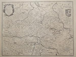
Landkarte der Grafschaft Mansfeld (Mansfeldia Comitatus).
Verlag: Selbstverlag, Frankfurt a. M., 1650
Anbieter: Antiquariat Hieronymus, M³nchen, Deutschland
Verkõuferbewertung 5 von 5 Sternen

Karte
Zustand: Gut. Gut. Kupferstich unter Passepartout, altkoloriert. Blattgr÷▀e: 32 x 38,5 cm, Druckspiegel: 29 x 36,3 cm. . Krõftiger, leicht kolorierter Druck auf etwas gebrõuntem, im Falz gering fleckigem Papier, insgesamt gut erhalten. Sch÷ne Karte der Grafschaft Mansfeld von Bernburg an der Saale bis Beichlingen und von Halle an der Saale bis Stolberg im Harz. Mit Kartusche und Wappen der Querfurt-Mansfeld. Aus: "Topographia Superioris Saxoniae Th³ringiae", Frankfurt am Main 1650. Landkarte, map, carte gķographique, carta geografica, Deutschland, Germany, Allemagne, Germania, Sachsen, Sachsen-Anhalt, Harz, Ostdeutschland, DDR. 1200 Gramm.
-

Kst.- Karte, n. T. Stella b. G. Blaeu, "Mansfeldia Comitatus".
Sprache: Franz÷sisch
Anbieter: Antiquariat Clemens Paulusch GmbH, Berlin, Deutschland
Verkõuferbewertung 5 von 5 Sternen
Karte
1638, 41 x 49,7 Mit gro▀en Wappen und fig. Kartusche. Zeigt auch den Unterharz. - Franz. Ausgabe.
-
Comitatus Mansfeldia. (Grafschaft Mansfeld) Kupferstichkarte von H. Hondius. Plattengr÷sse 38 x 50,5 cm.
Verlag: um, 1630
Sprache: Deutsch
Anbieter: Antiquariat im Schloss, Schwaigern, D, Deutschland
Verkõuferbewertung 5 von 5 Sternen
Karte
Gebiet zwischen Aschersleben im Norden, Rinderbruck im S³den sowie Walkenried im Westen und Rockendorff im Osten. Minimal angebrõunt. Sprache: Deutsch Gewicht in Gramm: 900.
-
"Mansfeldia Comitatus".
Anbieter: Antiquariat Peter Fritzen, Speicher, Deutschland
Verkõuferbewertung 5 von 5 Sternen
Karte
Kupferstich-Karte von Blaeu nach Stella, ca. 1635, altkoloriert. Ca. 41 x 50 cm. Rechts oben fig³rliche Titelkartusche mit Kampf zwischen Drachen und Putti, rechts unten Druckvermerk "Apud Guiljelm. Blaeu.", unten in der Mitte Meilenzeiger. Mit R³ckentext.
-

Mansfeldia Comitatus Auctore Tilemanno Stella Sig.
Erscheinungsdatum: 1655
Anbieter: Geographicus Rare Antique Maps, Brooklyn, NY, USA
Verbandsmitglied: ABAA ESA ILAB
Verkõuferbewertung 5 von 5 Sternen
Karte
Very good. Minor wear along original centerfold. Text on verso. Overall toning. Size 17 x 20.5 Inches. This beautiful 1655 map by Willem Blaeu represents Mansfeld and its surrounding regions, located in the western part of eastern Germany. Centered on Mansfeld, the map covers from Bernburg south as far as Kindelbruck, and from Stolberg eastward to Halle. Important cities and towns, including Berga, Frankenhausen, Kelbra, Alsleben, Aschersleben, and others are identified. Forests, marshes, rivers, lakes, towns, cities and mountains are beautifully rendered. A title cartouche in the upper right quadrant details two cherubs dressed as knights, one of which is fighting a dragon. The Mansfeld coat of arms is also included above the title. This map was created by Tilemanno Stella, known for his maps of the Holy Land and Germany. Martin Luther, the pioneer of the Protestant Reformation, lived and grew up in Mansfeld between 1488 and 1496. This map was issued by Willem Blaeu in 1655. References: Osher Map Library Antique Maps Collection, OL2403.
-

Kst.- Karte, b. H. Hondius, "Comitatus Mansfeldia".
Sprache: Deutsch
Anbieter: Antiquariat Clemens Paulusch GmbH, Berlin, Deutschland
Verkõuferbewertung 5 von 5 Sternen
Karte
1633, 38 x 49,7 Koeman's Atlantis Neerlandici, 2150: 1A (franz. Ausgabe). - Oben links die Titelkartusche, oben rechts ein gro▀es Wappen. Gebiet Aschersleben, Halle, Sondershausen, Walkenried.
-

Kst.- Karte, n. T. Stella b. G. Blaeu, "Mansfeldia Comitatus".
Sprache: Deutsch
Anbieter: Antiquariat Clemens Paulusch GmbH, Berlin, Deutschland
Verkõuferbewertung 5 von 5 Sternen
Karte
mit altem Grenz- und Flõchenkolorit, um 1640, 41 x 49,7 van der Krogt, Koeman's Atlantes Neerlandici 2150:2; dekorative Karte der Grafschaft Mansfeld, Titelkartusche oben rechts, dar³ber Gebietswappen, mit spanischem R³ckentext; mit der ³blichen Mittelfalz, sonst tadllos.
