Gesamtpreis (1 Artikel Artikel):
Versandziel:

nordamerika karte america (22 Ergebnisse)
Feedback
Direkt zu den wichtigsten Suchergebnissen
Suchfilter
Produktart
- Alle Product Types
- B¸cher (Keine weiteren Ergebnisse entsprechen dieser Verfeinerung)
- Magazine & Zeitschriften (Keine weiteren Ergebnisse entsprechen dieser Verfeinerung)
- Comics (Keine weiteren Ergebnisse entsprechen dieser Verfeinerung)
- Noten (Keine weiteren Ergebnisse entsprechen dieser Verfeinerung)
- Kunst, Grafik & Poster (15)
- Fotografien (Keine weiteren Ergebnisse entsprechen dieser Verfeinerung)
- Karten (7)
- Manuskripte & Papierantiquit‰ten (Keine weiteren Ergebnisse entsprechen dieser Verfeinerung)
Zustand
- Alle
- Neu (Keine weiteren Ergebnisse entsprechen dieser Verfeinerung)
- Antiquarisch (22)
Einband
- alle Einb‰nde
- Hardcover (1)
- Softcover (Keine weiteren Ergebnisse entsprechen dieser Verfeinerung)
Weitere Eigenschaften
- Erstausgabe (Keine weiteren Ergebnisse entsprechen dieser Verfeinerung)
- Signiert (Keine weiteren Ergebnisse entsprechen dieser Verfeinerung)
- Schutzumschlag (Keine weiteren Ergebnisse entsprechen dieser Verfeinerung)
- Angebotsfoto (16)
Sprache (3)
Gratisversand
- Kostenloser Versand nach USA (Keine weiteren Ergebnisse entsprechen dieser Verfeinerung)
Land des Verk‰ufers
Verk‰uferbewertung
-

Nordamerika Nebraska Iowa Alabama Cuba America Karte map Lithographie
Erscheinungsdatum: 1900
Sprache: Deutsch
Anbieter: Antiquariat Steffen Vˆlkel GmbH, Seubersdorf, Deutschland
Verk‰uferbewertung 5 von 5 Sternen

Karte
EUR 5,00
W‰hrung umrechnenEUR 32,00 f¸r den Versand von Deutschland nach USAAnzahl: 1 verf¸gbar
In den Warenkorbca.57 x45 cm. (M 6556) schˆne groþformatige Farb-Lithographie-Karte von ca. 1900 "VereinigteStaatenvonNordamerika" Blatt-Format: ca.57 x45 cm gut erhalten Original! - Keine Kopie! - Kein Nachdruck! Sprache: Deutsch.
-

Grˆnland Minneapolis New Orleans Nordamerika America Karte map Lithographie
Erscheinungsdatum: 1890
Sprache: Deutsch
Anbieter: Antiquariat Steffen Vˆlkel GmbH, Seubersdorf, Deutschland
Verk‰uferbewertung 5 von 5 Sternen
Karte
EUR 7,00
W‰hrung umrechnenEUR 32,00 f¸r den Versand von Deutschland nach USAAnzahl: 1 verf¸gbar
In den Warenkorbca.42 x54 cm. (MN 22546) "Nordamerika" schˆneOriginalFarblithographie - Kartevon ca. 1890 Blatt-Format: ca.42 x54 cm gut erhalten Sprache: Deutsch.
-
Nordamerika - (Karte von) Nord America mit Westindien. Gezeichnet von H. Kiepert. Gestochen v. W. Kratz.
Verlag: Weimar, Verlag des Geographischen Instituts,, 1853
Sprache: Deutsch
Anbieter: Altstadt Antiquariat M. Weiers, Freiburg, Deutschland
Verk‰uferbewertung 5 von 5 Sternen
Karte
EUR 154,00
W‰hrung umrechnenEUR 20,00 f¸r den Versand von Deutschland nach USAAnzahl: 1 verf¸gbar
In den WarenkorbZustand: Gut. Mit farbigem Grenzkolorit. Leichte Gebrauchsspuren. L Sprache: Deutsch Gewicht in Gramm: 550 60 x 51 cm. In 20 Segmenten original auf Leinwand montiert. Im marmor. Orig.-Schuber.
-

"Etats-Unis" - North America Nordamerika / Texas United States / manuscript / map Karte / Zeichnung dessin drawing
Verlag: c. 1850., 1850
Sprache: Deutsch
Anbieter: Antiquariat Steffen Vˆlkel GmbH, Seubersdorf, Deutschland
Verk‰uferbewertung 5 von 5 Sternen
Kunst / Grafik / Poster
EUR 39,99
W‰hrung umrechnenEUR 32,00 f¸r den Versand von Deutschland nach USAAnzahl: 1 verf¸gbar
In den WarenkorbMaþe: ca. 29 x 39,5 cm. -- Federzeichnung. -- mit Knickspuren, teils mit Nadellˆchern, sonst gut erhalten. || Ink drawing. -- with creases, partly with pinholes, otherwise in very good condition. Sprache: Deutsch Gewicht in Gramm: 1500.
-
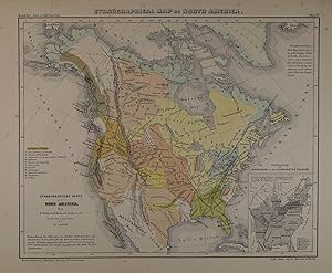
Ethnographical Map of North America. Farblithographierte Karte von Leopold Kraatz in Berlin aus Henry Lange, "Kartenwerk zu Karl Andree's Nordamerika" Braunschweig, Westermann 1854, 21,5 x 27 cm
Anbieter: Antiquariat Johannes M¸ller, Salzburg, ÷sterreich
Verk‰uferbewertung 5 von 5 Sternen
Karte
Tooley Dictionary S. 375.- Ethnographische Karte von Nordamerika mit den Stammesgebieten und -namen der indigenen Urbevˆlkerung. Rechts unten kleine Nebenkarte: "Verbreitung der Deutschen in den Vereinigten Staaten".-# Rare lithographed map with small Inset-map of the original German settlement areas.-.
-

NORTH AMERICA, PHYSICAL MAP / NORDAMERIKA PHYSISCHE KARTE, BONNEFONT / VUILLEMIN 1885 Titel: AmÈrique du Nord Physique.; par L. Bonnefont; GravÈ par Erhard; dressÈ par A. Vuillemin
Verlag: LanÈe Editeur ca. 1885, Paris, 1885
Anbieter: ANTIQUARIAT.WIEN Fine Books & Prints, Wien, ÷sterreich
Verk‰uferbewertung 5 von 5 Sternen
Karte
EUR 66,00
W‰hrung umrechnenEUR 42,00 f¸r den Versand von ÷sterreich nach USAAnzahl: 1 verf¸gbar
In den Warenkorboriginal map, original Landkarte, mehrf‰rbig, Blatt ca. 32,5 x 42 cm ORIGINAL MAP /ORIGINALE LANDKARTE // Louis Bonnefont, Alexandre Aime? Vuillemin (1812-); Bonacker 232 de 500 Landkarte.
-

"Mondo Nuovo" - North America Nordamerika Amerika California Canada Florida map Karte
Verlag: Padova, Paolo & Francesco Galignani, 1620
Sprache: Italienisch
Anbieter: Antiquariat Steffen Vˆlkel GmbH, Seubersdorf, Deutschland
Verk‰uferbewertung 5 von 5 Sternen
Karte
EUR 650,00
W‰hrung umrechnenEUR 32,00 f¸r den Versand von Deutschland nach USAAnzahl: 1 verf¸gbar
In den WarenkorbOriginal Kupferstich-Karte aus Tomaso Porcacchi: "L'isole piu famose del mondo". Auf vollem Textblatt. -- Blatt-Maþe: ca. 26,5 x 19 cm. Plattenmaþe: ca. 11 x 15 cm. -- am unteren Auþenrand mit kleiner hinterlegter Wurmspur (mit leichtem Textverlust), sonst gut erhalten. || Original copper engraved map out of Tomaso Porcacchi's book "L'isole piu famose del mondo". On full text page. -- with a restored wormhole on the lower outer margin (with only a minor loss of text), otherwise in good condition. Sprache: Italienisch Gewicht in Gramm: 10.
-

"Carte Tres Curieuse De La Mer Du Sud Contenant Des Remarques Nouvelles Et Tres Utiles Non Seulement Sur Les Ports et Isles de Cette Mer, Mais aussy sur les principaux Pays de l'Amerique tant Septentrionale que Meridionale, Avec les Noms & la Route des Voyageurs par qui la decouvertÈ en a ÈtÈ faite. Le tour pour l'intelligence Des Dissertations suivantes." - North America Nordamerika Amerika California wall map Karte
Verlag: Amsterdam, 1720
Sprache: Deutsch
Anbieter: Antiquariat Steffen Vˆlkel GmbH, Seubersdorf, Deutschland
Verk‰uferbewertung 5 von 5 Sternen
Karte
EUR 9.500,00
W‰hrung umrechnenEUR 32,00 f¸r den Versand von Deutschland nach USAAnzahl: 1 verf¸gbar
In den WarenkorbOriginal Kupferstich von H. A. Chatelain (1684-1743) von ca. 1720. -- Von 4 Platten gedruckt; zusammensetzbar. -- Blatt-Maþe: jede Karte ca. 140 x 44 cm. -- an den Seitenr‰ndern knapprandig, sonst gut erhalten. || Original copper engraving by H. A. Chatelain (1684-1743) from c. 1720. -- Printed on 4 plates, can be joined together. -- with narrow margins on the sides, otherwise in very good condition. || An extremely interesting example of a wall map of exceptional intricacy and detail. It was called "one of the most decorative maps of North America of the 18th century" (Tooley). Its complex illustrations provide a panorama of the Discovery Period, depicting the mores, rituals and practices of indigenous peoples thought to be exotic by Europeans at the time. There are historic episodes depicted, New World flora and fauna, and portraits of the great discoverers. Two of the more prominent illustrations depict a very industrious and human-like beaver colony and the sun drying of cod fish in Newfoundland. Both of these commodities were common of the early economy of North America. The map with its lush imagery may also be viewed as the mapmaker's attempt to stimulate interest in pan-Pacific trade. The map's presentation of an undersized Pacific Ocean, with voyage tracks showing direct and easy crossings, certainly makes the ocean appear less than forbidding. The map was engraved by Bernard Picart. It also includes many of the lands of the eastern Pacific Rim, making clear that vast territories would be accessible via Pacific voyages. And the hyper-rich imagery also suggests the potential rewards of such an effort. The map was also one of the most elaborate examples of pictorial geography that was popular at the time. In the first half of the 18th century, there were many works published with richly illustrated maps in order to convey both history and geography at the same time. Although California is still shown as an island on the map, it is done so with some uncertainty. (California was first depicted as an island in the 1620s, but by the time this map appeared, the myth was beginning to wane.) A notation states "moderns" believe it to belong to the mainland, and the island is engraved with a fainter, thus less definitive line. Sprache: Deutsch Gewicht in Gramm: 1550.
-

NORDAMERIKA. - Karte. "North America".
Anbieter: Peter Bierl Buch- & Kunstantiquariat Inh.: Andrea Bierl, Eurasburg, Deutschland
Verk‰uferbewertung 5 von 5 Sternen
Kunst / Grafik / Poster
EUR 38,00
W‰hrung umrechnenEUR 40,00 f¸r den Versand von Deutschland nach USAAnzahl: 1 verf¸gbar
In den WarenkorbGrenzkol. Stahlstich bei Johnston, 1883, 42,5 x 32 cm.
-

NORDAMERIKA. - Karte. "Nord-America".
Anbieter: Peter Bierl Buch- & Kunstantiquariat Inh.: Andrea Bierl, Eurasburg, Deutschland
Verk‰uferbewertung 5 von 5 Sternen
Kunst / Grafik / Poster
EUR 70,00
W‰hrung umrechnenEUR 40,00 f¸r den Versand von Deutschland nach USAAnzahl: 1 verf¸gbar
In den WarenkorbFarblithographie aus Adami-Kiepert bei Reimer, 1876, 25 x 33 cm. Espenhorst, PP Anm. 27, S. 778. - Aus: Adami-Kiepert's "Schul-Atlas" (Ausgabe 1876).
-

NORDAMERIKA. - Karte. "Nord America". Gesamtkarte, mit Mittelamerika.
Anbieter: Peter Bierl Buch- & Kunstantiquariat Inh.: Andrea Bierl, Eurasburg, Deutschland
Verk‰uferbewertung 5 von 5 Sternen
Kunst / Grafik / Poster
EUR 75,00
W‰hrung umrechnenEUR 40,00 f¸r den Versand von Deutschland nach USAAnzahl: 1 verf¸gbar
In den WarenkorbGrenzkol. Stahlstich von Biller aus Galletti bei Hartleben, 1840, 20 x 25 cm. Espenhorst, PP 45.1.1. - Aus: J.G.A. Galletti's "Allgemeine Weltkunde" (9. Ausgabe 1840). - F¸nf Karten "neu gestochen von F(ranz) Biller . wunderschˆn von Hand koloriert" (Espenhorst, PP, S. 1143). - Zeigt Texas, Neu Mexiko und Kalifornien noch zu Mexiko.
-

NORDAMERIKA. - Karte. "Nord America". Gesamtkarte, mit Mittelamerika.
Anbieter: Peter Bierl Buch- & Kunstantiquariat Inh.: Andrea Bierl, Eurasburg, Deutschland
Verk‰uferbewertung 5 von 5 Sternen
Kunst / Grafik / Poster
EUR 85,00
W‰hrung umrechnenEUR 40,00 f¸r den Versand von Deutschland nach USAAnzahl: 1 verf¸gbar
In den WarenkorbAltkol. Stahlstich von Biller aus Galletti bei Hartleben, 1840, 20 x 25 cm. Espenhorst, PP 45.1.1. - Aus: J.G.A. Galletti's "Allgemeine Weltkunde" (9. Ausgabe 1840). - F¸nf Karten "neu gestochen von F(ranz) Biller . wunderschˆn von Hand koloriert" (Espenhorst, PP, S. 1143). - Zeigt Texas, Neu Mexiko und Kalifornien noch zu Mexiko.
-

NORDAMERIKA. - Karte. "Nord-America". Gesamtkarte.
Anbieter: Peter Bierl Buch- & Kunstantiquariat Inh.: Andrea Bierl, Eurasburg, Deutschland
Verk‰uferbewertung 5 von 5 Sternen
Kunst / Grafik / Poster
EUR 90,00
W‰hrung umrechnenEUR 40,00 f¸r den Versand von Deutschland nach USAAnzahl: 1 verf¸gbar
In den WarenkorbGrenzkol. Kupferstich von Behrens nach St¸lpnagel aus Stieler bei Perthes, Gotha, 1875, 31 x 38 cm. Espenhorst, PP 2.1.1.1.6. - Aus: A. Stieler's "Hand-Atlas" (6. Ausgabe, Auflage 1875).
-

NORDAMERIKA. - Karte. "Nord America". Gesamtkarte. Mit Nebenkarte "Die Aleuten".
Anbieter: Peter Bierl Buch- & Kunstantiquariat Inh.: Andrea Bierl, Eurasburg, Deutschland
Verk‰uferbewertung 5 von 5 Sternen
Kunst / Grafik / Poster
EUR 98,00
W‰hrung umrechnenEUR 40,00 f¸r den Versand von Deutschland nach USAAnzahl: 1 verf¸gbar
In den WarenkorbGrenzkol. Kupferstich nach Weiland, Weimar im Geograph. Institut, dat. 1829, 59 x 53,5 cm. Espenhorst, PP 1.1.2. - Mit Alaska als "Russische Besitzungen". - Unten und links durchgehend wasserrandig.
-

NORDAMERIKA. - Karte. "Nord-America". Gesamtkarte.
Anbieter: Peter Bierl Buch- & Kunstantiquariat Inh.: Andrea Bierl, Eurasburg, Deutschland
Verk‰uferbewertung 5 von 5 Sternen
Kunst / Grafik / Poster
EUR 110,00
W‰hrung umrechnenEUR 40,00 f¸r den Versand von Deutschland nach USAAnzahl: 2 verf¸gbar
In den WarenkorbGrenzkol. Kupferstich von Felberthann aus Kiepert bei Reimer, Berlin, 1861, 44,5 x 55 cm. Espenhorst, PP 20.1.1. - Aus: Heinrich Kiepert's "Neuer Handatlas ¸ber alle Theile der Erde" (Ausgabe 1861). - Berichtigt 1860. - Gesamtkarte mit Mittelamerika, der Karibik und den Antillen.
-
NORDAMERIKA. - Karte. "Nord-America". Gesamtkarte.
Anbieter: Peter Bierl Buch- & Kunstantiquariat Inh.: Andrea Bierl, Eurasburg, Deutschland
Verk‰uferbewertung 5 von 5 Sternen
Kunst / Grafik / Poster
EUR 110,00
W‰hrung umrechnenEUR 40,00 f¸r den Versand von Deutschland nach USAAnzahl: 1 verf¸gbar
In den WarenkorbGrenzkol. Kupferstich von Sulzer und Barth aus Kiepert bei Reimer, Berlin, 1871, 44,5 x 55 cm. Espenhorst, PP 20.1.2. - Aus: Heinrich Kiepert's "Neuer Handatlas ¸ber alle Theile der Erde" (Ausgabe 1871). - Berichtigt 1870. - Gesamtkarte mit Mittelamerika, der Karibik und den Antillen.
-
NORDAMERIKA. - Karte. "Nord-America". Gesamtkarte.
Anbieter: Peter Bierl Buch- & Kunstantiquariat Inh.: Andrea Bierl, Eurasburg, Deutschland
Verk‰uferbewertung 5 von 5 Sternen
Kunst / Grafik / Poster
EUR 110,00
W‰hrung umrechnenEUR 40,00 f¸r den Versand von Deutschland nach USAAnzahl: 1 verf¸gbar
In den WarenkorbGrenzkol. Kupferstich von Sulzer und Barth aus Kiepert bei Reimer, Berlin, 1875, 44,5 x 55 cm. Espenhorst, PP 20.1.2. - Aus: Heinrich Kiepert's "Neuer Handatlas ¸ber alle Theile der Erde" (Ausgabe 1875). - Berichtigt 1874. - Gesamtkarte mit Mittelamerika, der Karibik und den Antillen.
-
NORDAMERIKA. - Karte. "Nord-America". Gesamtkarte.
Anbieter: Peter Bierl Buch- & Kunstantiquariat Inh.: Andrea Bierl, Eurasburg, Deutschland
Verk‰uferbewertung 5 von 5 Sternen
Kunst / Grafik / Poster
EUR 110,00
W‰hrung umrechnenEUR 40,00 f¸r den Versand von Deutschland nach USAAnzahl: 1 verf¸gbar
In den WarenkorbGrenzkol. Kupferstich von Felberthann aus Kiepert bei Reimer, Berlin, 1858, 44,5 x 55 cm. Espenhorst, PP 20.1.1. - Aus: Heinrich Kiepert's "Neuer Handatlas ¸ber alle Theile der Erde" (Ausgabe 1858). - Gesamtkarte mit Mittelamerika, der Karibik und den Antillen.
-

NORDAMERIKA. - Karte. "Nord-America".
Anbieter: Peter Bierl Buch- & Kunstantiquariat Inh.: Andrea Bierl, Eurasburg, Deutschland
Verk‰uferbewertung 5 von 5 Sternen
Kunst / Grafik / Poster
EUR 130,00
W‰hrung umrechnenEUR 40,00 f¸r den Versand von Deutschland nach USAAnzahl: 2 verf¸gbar
In den WarenkorbStahlstich mit Farblithographie nach Ravenstein aus Meyer bei BI, um 1865, 33,5 x 43,5 cm. Espenhorst, PP 3.4 (Meyer-Ravenstein 1862-1884). - Aus: Joseph Meyer's "Hand-Atlas", redigiert von Ludwig Ravenstein (1838-1915).
-
NORDAMERIKA. - Karte. "Nord America mit Westindien". Gesamtkarte. Mit Nebenkarte f¸r die Aleuten.
Anbieter: Peter Bierl Buch- & Kunstantiquariat Inh.: Andrea Bierl, Eurasburg, Deutschland
Verk‰uferbewertung 5 von 5 Sternen
Kunst / Grafik / Poster
EUR 148,00
W‰hrung umrechnenEUR 40,00 f¸r den Versand von Deutschland nach USAAnzahl: 1 verf¸gbar
In den WarenkorbGrenzkol. Kupferstich von Kratz nach Kiepert, Weimar im Geograph. Institut, dat. 1856, 59,5 x 51 cm. Espenhorst, PP 1.1.5. - Mit Alaska als "Russisches Nordamerika".
-
NORDAMERIKA. - Karte. "Nord America mit Westindien". Mit Anschluþkarte.
Anbieter: Peter Bierl Buch- & Kunstantiquariat Inh.: Andrea Bierl, Eurasburg, Deutschland
Verk‰uferbewertung 5 von 5 Sternen
Kunst / Grafik / Poster
EUR 150,00
W‰hrung umrechnenEUR 40,00 f¸r den Versand von Deutschland nach USAAnzahl: 2 verf¸gbar
In den WarenkorbGrenzkol. Kupferstich von Wibel/Poppey nach Kiepert/Ohmann, Weimar im Geograph. Institut, 1872, 59 x 51 cm. Espenhorst, PP 1.1.6. - Aus: Heinrich Kiepert's "Grosser Hand-Atlas" (43. Ausgabe, Auflage 1872). - Gewann 1871 die einzige Goldmedaille auf dem Geographenkongreþ in Antwerpen (PP, S. 111). - Die Anschluþkarte zeigt "Die nordwestlichen Inselgruppen Amerikas" (Behrings Meer).
-

AMERIKA. - Karte. "Geographical, historical, and statistical Map of America". Karte von Nordamerika (22,5 x 21 cm) neben S¸damerika (22,5 x 17,5 cm), umgeben von umfangreichen Beschreibungen.
Anbieter: Peter Bierl Buch- & Kunstantiquariat Inh.: Andrea Bierl, Eurasburg, Deutschland
Verk‰uferbewertung 5 von 5 Sternen
Kunst / Grafik / Poster
EUR 220,00
W‰hrung umrechnenEUR 40,00 f¸r den Versand von Deutschland nach USAAnzahl: 1 verf¸gbar
In den WarenkorbAltkol. Kupferstich von J. Walker, dat. 1828, 42 x 51 cm. Befasst sich neben geschichtlichen und statistischen Daten auch mit den Reisen von Columbus, Cortez und Pizarro.