Gesamtpreis (1 Artikel Artikel):
Versandziel:

nova totius terrarum orbis geographica, Gebraucht (20 Ergebnisse)
Feedback
Direkt zu den wichtigsten Suchergebnissen
Suchfilter
Produktart
- Alle Product Types
- Bücher (5)
- Magazine & Zeitschriften (Keine weiteren Ergebnisse entsprechen dieser Verfeinerung)
- Comics (Keine weiteren Ergebnisse entsprechen dieser Verfeinerung)
- Noten (Keine weiteren Ergebnisse entsprechen dieser Verfeinerung)
- Kunst, Grafik & Poster (3)
- Fotografien (Keine weiteren Ergebnisse entsprechen dieser Verfeinerung)
- Karten (12)
- Manuskripte & Papierantiquitäten (Keine weiteren Ergebnisse entsprechen dieser Verfeinerung)
Zustand
- Alle
- Neu (Keine weiteren Ergebnisse entsprechen dieser Verfeinerung)
- Antiquarisch (20)
Einband
Weitere Eigenschaften
- Erstausgabe (Keine weiteren Ergebnisse entsprechen dieser Verfeinerung)
- Signiert (1)
- Schutzumschlag (Keine weiteren Ergebnisse entsprechen dieser Verfeinerung)
- Angebotsfoto (19)
Sprache (4)
Gratisversand
- Kostenloser Versand nach USA (Keine weiteren Ergebnisse entsprechen dieser Verfeinerung)
Land des Verkäufers
Verkäuferbewertung
-

Reading the World: Interdisciplinary Perspectives on Pieter van den Keere's Map, Nova Totius Terrarum Orbis Geographica as Hydrographica Tabula (Amsterdam 1608/36) *SIGNED*
Verlag: Portland, ME : Osher Map Library/University of Southern Maine, 2001
ISBN 10: 093956131X ISBN 13: 9780939561315
Sprache: Englisch
Signiert
EUR 22,00
Währung umrechnenEUR 15,00 für den Versand von Niederlande nach USAAnzahl: 1 verfügbar
In den WarenkorbZustand: Good. Paperback, b/w illustrations, oblong (circa 21.5x28cm) Signed by Matthew H. Edney and Irwin D. Novak on title page and by Alfred Padula, Craig Dietrich and Donna M. Cassidy (contributors) on Table of Contents page.
-
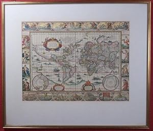
Nova Totius Terrarum Orbis Geographica Ac Hydrographica Tabula auct Guiljelmo Blaeuw. Kolerierter Nachdruck. Motivgröße 12 x 16 cm // Blattgröße 20 x 25 cm //. Ungerasterter Druck mit Plattenrand auf starkem Bütten. Dekorative Karte, umrahmt mit bildlichen Darstellungen der vier Elemente, sieben Weltwunder, sieben Planeten und vier Jahreszeiten.
Verlag: Ohne Verlag, um 1970 ???, Ohne Ort,, 1970
Anbieter: Umbras Kuriositätenkabinett, Berlin, Deutschland
Verkäuferbewertung 5 von 5 Sternen

Kunst / Grafik / Poster
EUR 16,00
Währung umrechnenEUR 19,98 für den Versand von Deutschland nach USAAnzahl: 1 verfügbar
In den Warenkorb20 x 25 cm. 1 Blatt. . ISBN: Keine. Kartoniert / Soft cover. No jacket. Kartoniert / Soft cover. 1. Auflage. Sprache: de. * Versandfertig innerhalb von 20 Stunden! Meersburg ist eine Kleinstadt im baden-württembergischen Bodenseekreis. Sie liegt zwischen Friedrichshafen und Überlingen. R1B2. (Rad). Jpg.
-
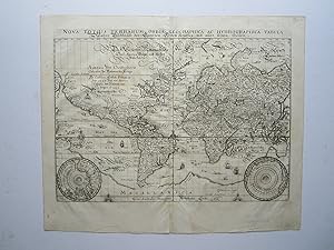
Nova Totius Terrarum Orbis Geographica ac Hydrographi Emendata [Reprint]
Verlag: Stuttgart, Schuler, 1994
Sprache: Deutsch
Anbieter: avelibro OHG, Dinkelscherben, Deutschland
Verbandsmitglied: BOEV
Verkäuferbewertung 5 von 5 Sternen
Karte
EUR 20,00
Währung umrechnenEUR 26,41 für den Versand von Deutschland nach USAAnzahl: 1 verfügbar
In den WarenkorbKarte. Zustand: Sehr gut. 1 Bl. Faksimile der illustrierten Weltkarte des Pieter Verbists, basierend auf dem Original, das 1636 in Antwerpen erschien. Karte ist in einem sehr guten, fast neuwertigen Zustand. B12-02-06Ga Sprache: Deutsch Gewicht in Gramm: 32.
-
Nova Totius Terrarum Orbis Geographica Ac Hydrographica Tabula. Farbiger Reprint einer Weltkarte, umgeben von zahlreichen Ansichten berühmter Eroberer und Feldherren sowie kleineren Stadt- und Landschaftsansichten
Verlag: Selbstverlag
Sprache: Latein
Anbieter: ABC Versand e.K., Aarbergen, Deutschland
Verkäuferbewertung 5 von 5 Sternen
Karte
EUR 59,70
Währung umrechnenEUR 8,31 für den Versand von Deutschland nach USAAnzahl: 1 verfügbar
In den Warenkorbausgefaltet ca. 39 x 32 cm. Zustand: Sehr gut. Karte Farbiger Nachdruck einer Weltkarte, Unterkante sehr leicht bestoßen, Karte sonst sehr gut erhalten, ohne Jahresangabe, Sprache: Latein Ordner28 la Gewicht in Gramm: 201.
-
Nova totius terrarum orbis geographica ac hydrographica tabula: America. Anno domini 1492 a Christophoro Columbo nomine Regis Casthelle primum detecta (.). Farbiger Offsetdruck nach der um ca. 1680 gedruckten Karte von Wil. Blaeuw. Unter Passepartout in vergoldetem Holzleisten-Rahmen.
Erscheinungsdatum: 1970
Anbieter: Versandantiquariat Bürck (VDA / ILAB), Berlin, Deutschland
Verbandsmitglied: GIAQ ILAB VDA
Verkäuferbewertung 5 von 5 Sternen
EUR 53,90
Währung umrechnenEUR 12,00 für den Versand von Deutschland nach USAAnzahl: 1 verfügbar
In den WarenkorbHardcover. Zustand: Gut. (Um 1970). Bildgrösse ca. 24,5 x 33 cm, Rahmengrösse ca. 39,5 x 46 cm. (Rahmen mit nur kl. Absplitterungen, nicht ausgerahmt, aber augenscheinlich gut erhalten). Dekorative Karte, die Darstellung mit Kartuschen und Meilenzähler, umrahmt mit allegorischen Darstellungen der Elemente, Weltwunder, Planeten und Jahreszeiten.
-

Nova totius terrarum orbis geographica ac hydrographica tabula. Wahre Biltnüß des Gantzen Erden Krayses mit allen seinen theilen.
Verlag: [Frankfurt a. M., Matthäus Merian], o. J. (um 1640)., 1640
Sprache: Latein
Anbieter: Versandantiquariat Wolfgang Friebes, Graz, Österreich
Verkäuferbewertung 5 von 5 Sternen
EUR 200,00
Währung umrechnenEUR 24,80 für den Versand von Österreich nach USAAnzahl: 1 verfügbar
In den WarenkorbZustand: 0. Links oben ein gedruckter Text zur Entdeckung Amerikas durch Christoph Columbus, die beiden unteren Ecken mit den Darstellungen der Pole. - Die vor allem an den Seiten knapp beschnittene Karte wurde wohl in der zweiten Hälfte des 20. Jahrhunderts auf einfachem braunem Karton aufgezogen (dabei mehrere tlw. längere Risse in der Darstellung geschlossen). Mittig vertikal gefaltet. Tlw. fleckig. - Erhaltung im Preis berücksichtigt; Fotos auf Anfrage! - Shirley 345. la Gewicht in Gramm: 350 Kupferkarte, 29 x 36 cm (Blattgröße), in der Platte sign. M. Merian fecit".
-

'NOVA TOTIUS TERRARUM ORBIS GEOGRAPHICA AC HYDROGRAPHICA TABULA / WAHRE BILDTNÜSS DES GANTZEN ERDEN KRAYSES MIT ALLEN SEINEN THEILEN'. Map of the world on Mercator's projection with two small inset polar spheres. Engraved by Merian and published by
Verlag: Johann Ludwig Gottfried in Frankfurt 1646, 1646
Anbieter: Garwood & Voigt, Sevenoaks, Vereinigtes Königreich
Verkäuferbewertung 5 von 5 Sternen
Karte
EUR 1.504,86
Währung umrechnenEUR 40,91 für den Versand von Vereinigtes Königreich nach USAAnzahl: 1 verfügbar
In den WarenkorbZustand: Fine. 26x36cm. Full hand colour. Excellent condition. Shirley 345.
-

Nova Totius Terrarum Orbis Geographica ac Hydrographica Tabula
Verlag: Artist: Hondius Hendrik ( - 1650 ) Amsterdam; issued in: Paris; - Jodocus Hondius (1563 ?1612) was a Dutch engraver and cartographer He is best known for his early maps of the New World and Europe for re-establishing the reputation of the work of Gerard Mercator and for his portraits of Francis Drake He helped establish Amsterdam as the center of cartography in Europe in the 17th century He was born in Wakken and grew up in Ghent In his early years he established himself as an engraver instrument maker and globe maker In 1584 he moved to London to escape religious difficulties in Flanders While in England Hondius was instrumental in publicizing the work of Francis Drake who had made a circumnavigation of the world in the late 1570s In parti, 1597
Anbieter: Antique Sommer& Sapunaru KG, München, Deutschland
Verkäuferbewertung 2 von 5 Sternen

EUR 6.650,00
Währung umrechnenEUR 45,00 für den Versand von Deutschland nach USAAnzahl: 1 verfügbar
In den WarenkorbTechnic: Copper print, colorit: coloredcondition: Margins on the right and left professionally completed, size (in cm): 38 x 53 cm; - World map in 2 hemispheres and the northern and southern signs of the zodiac, California as an island. Magnificent depictions of the 4 seasons, spring, summer, autumn and winter in the corners of the map. Also splendid representations of the 4 earth elements, fire, water, air and earth.
-

Nova totius terrarum orbis geographica ac hydrographica tabula
Verlag: Amsterdam, 1630
Anbieter: Libreria Ex Libris ALAI-ILAB/LILA member, Roma, Italien
Verkäuferbewertung 4 von 5 Sternen

Karte
EUR 13.000,00
Währung umrechnenEUR 30,00 für den Versand von Italien nach USAAnzahl: 1 verfügbar
In den WarenkorbCarta geografica originale (cm. 54,5x38 piů margini bianchi). Splendida coloritura coeva all'acquarello. Testo in lingua latina al verso. Esemplare in eccellente stato di conservazione. Primo stato di quattro. Molto rara. Splendido mappamondo in due emisferi opera di uno dei piů celebri cartografi di tutti i tempi, icona dell'epoca d'oro della cartografia olandese. La carta č decorata nei quattro angoli con i ritratti di Tolomeo, Hondius, Mercator e Giulio Cesare. Nella parte superiore č presente il globo celeste abbellito con festoni mentre, nella parte inferiore, la figura allegorica dell'Europa riceve doni dall'Africa, dall'Asia e dall'America, rappresentazione che riflette il dominio delle potenze marittime europee all'epoca. Ai lati sono raffigurati come di consueto i quatto elementi, Fuoco, Aria, Terra e Acqua. Nei due emisferi si possono notare inoltre tre piccoli pannelli, uno dei quali descrive la scoperta dell'America da parte di Cristoforo Colombo.Per i dettagli geografici Hondius seguě John Speed ed i suoi contemporanei e anch'egli presenta la California come un'isola. Le innovazioni riguardano in particolare la costa settentrionale dell'Australia che si estende verso la Nuova Guinea e un nuovo disegno del nord-est del Canada con l'Isola di Baffin (indicata come 'Queen Anne's forland') ora mostrata completamente circondata dal mare. In America meridionale, lo Stretto di Le Maire appare adesso ad est dello Stretto di Magellano. Va considerato che lo Stretto di Le Maire era stato scoperto solo quindici anni prima la pubblicazione di questa carta. Cfr. Shirley, 'The mapping of the world', n. 336.
-
'NOVA TOTIUS TERRARUM ORBIS GEOGRAPHICA AC HYDROGRAPHICA TABULA / WAHRE BILDTNÜSS DES GANTZEN ERDEN KRAYSES MIT ALLEN SEINEN THEILEN'. Map of the world on Mercator's projection with two small inset polar spheres. Engraved by Merian and published by
Verlag: Johann Ludwig Gottfried in Frankfurt 1638, 1638
Anbieter: Garwood & Voigt, Sevenoaks, Vereinigtes Königreich
Verkäuferbewertung 5 von 5 Sternen
Karte
EUR 1.203,89
Währung umrechnenEUR 40,91 für den Versand von Vereinigtes Königreich nach USAAnzahl: 1 verfügbar
In den WarenkorbZustand: Fine. 26x36cm. Excellent condition. Uncoloured as originally published. Shirley 345.
-
Nova Totius Terrarum Orbis Geographica ac Hydrographica Tabula Wahre Bildtnüß des Gantzen Erden Krayses mit allen seinen Theilen.
Verlag: anon, Frankfurt, 1646
Anbieter: Angelika C. J. Friebe Ltd. - MapWoman, Dorking, Vereinigtes Königreich
Verkäuferbewertung 5 von 5 Sternen
Karte
EUR 1.444,66
Währung umrechnenEUR 23,38 für den Versand von Vereinigtes Königreich nach USAAnzahl: 1 verfügbar
In den WarenkorbNo Binding. Zustand: Very Good. copper engraved map; overall 33 x 39,5 cm, plate 26 x 35,5 cm. fold as issued; some waterstains; add. printer's creases; split lower c'fold not affecting image; c'fold slightly warped; o/w vg cond. This very detailed map of the World is from Merian's Neuwe Archontologia Cosmica, published from 1646 onwards and based on his earlier map, first issued in 1638. According to Shirley, there are subtle differences the most important one being the absence of Merian's signature. Shirley (World) # 369.
-
Nova totius terrarum orbis geographica ac hydrographica tabula
Verlag: Francoforte, 1649
Anbieter: Libreria Ex Libris ALAI-ILAB/LILA member, Roma, Italien
Verkäuferbewertung 4 von 5 Sternen
Karte
EUR 1.400,00
Währung umrechnenEUR 30,00 für den Versand von Italien nach USAAnzahl: 1 verfügbar
In den WarenkorbIncisione originale su rame (cm. 36x27,5 piů margini) tratta dall'opera 'Archontologia cosmica, sive Imperiorum, regnorum, principatuum, rerumque publicarum omnium per totum terrarum orbem commentarii.' di Pierre d'Avity. Carta vergellata con filigrana. Raffinata coloritura all'acquarello. Margini laterali bianchi aggiunti, ma ottimo esemplare.
-
Nova Totius Terrarum Orbis Geographica, M.Pitt, 1680
Verlag: Pitt Moses, 1639-1697, 1680
Anbieter: Hammelburger Antiquariat, Hammelburg, Deutschland
Verkäuferbewertung 4 von 5 Sternen
Karte
EUR 12.000,00
Währung umrechnenEUR 30,00 für den Versand von Deutschland nach USAAnzahl: 1 verfügbar
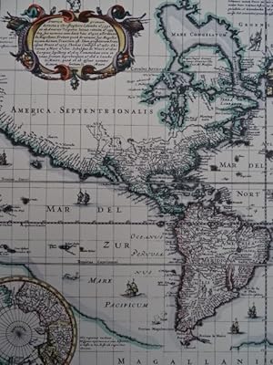
In den WarenkorbKein Einband. Zustand: Gut. Nova Totius Terrarum Orbis Geographica, M.Pitt, 1680 Nova Totius Terrarum Orbis Geographica ac Hydrographica Tabula Moses Pitt Antique map chart Nova Totius Terrarum Orbis Geographica ac Hydrographica Date: 1680 Publication: The English Atlas This beautiful map is one of the most intriguing examples of the internal workings of the map publishing business in the seventeenth century. The copperplate from which the map was printed was originally engraved by Pieter van den Keere (Petrus Kaerius) in 1608. It then passed into the hands of Jan Jansson in 1620, and finally to Jansson s heirs who formed a partnership with the Englishman, Moses Pitt. The plate was reworked several times and a comparison of the various states provide a compelling view of the changing image of the world during the 17th century. In this final state, the classic carte-a-figures borders remain unchanged, while the map itself was updated with actual discoveries such as Australia, Tierra del Fuego and the straits of Magellan and Le Maire. Other changes reflect prevailing, but erroneous, theories such as an insular California, a peculiar isthmus linking Nova Zembla to northern Asia, and a revived huge Antarctic landmass. The map is very scarce because Pitt s ambitious atlas project was a commercial failure; resulting in his confinement in debtor s prison. This map is a classic example of the mapmaker's art with carte-a-figures borders depicting allegorical representations of the sun, moon, the five known planets, the four elements and the four seasons. Along the bottom are vignettes showing the seven wonders of the world: the Hanging Gardens of Babylon, the Colossus over the harbor at Rhodes, the Pyramids, the Mausoleum of Halicarnassus at Cairo, the Temple of Diana, the Statue of Jupiter and the lighthouse at Alexandria. Size of the sheet: 60 x 68 cm., of the printed area: 39 x 53 cm. The map is printed on thick paper, little brownish centerfold, small restored wormhole on centerfold, handcoloured.
-
Nova totius Terrarum Orbis Geographica ac Hydrographica tabula. Altkolorierte Kupferstichkarte von J. van den Ende aus:
Verlag: Amsterdam, Blaeu, ca. 1635., 1635
Sprache: Deutsch
Anbieter: Matthaeus Truppe Antiquariat, Graz, Österreich
Verkäuferbewertung 5 von 5 Sternen
Karte
EUR 11.556,00
Währung umrechnenEUR 38,00 für den Versand von Österreich nach USAAnzahl: 1 verfügbar
In den WarenkorbCa. 41 cm x 55,5 cm. Koeman Bl 5, 1. Shirley 255. - Der vierte Zustand (Guiljelmo Blaeuw und ohne Datierung) dieser wohl shönsten Weltkarte des 17. Jahrhunderts. "It is celebrated as one of the supreme examples of the map maker`s art" (Shirley, S. 270). - Die Weltkarte, nach Mercators Projektion, ist umgeben von 4 Bildleisten und 2 kleinen Polkarten am unteren Rand. An den Seiten Allegorien der 4 Jahreszeiten und Elemente, am oberen Rand mittig Allegorie auf die Sonne flankiert von Allegorien des Mondes und von 5 Planeten, am unteren Rand Darstellung der sieben Weltwunder. Interessant auch der kurze Text zur Entdeckung von Amerika in der Kartusche. - Verso deutscher Text. - Leicht gebräunt und fleckig. Restaurierte Läsuren in den Rändern und im Falz. Die beiden oberen Ecken mit ergänzten Einrissen (aber ohen Bildberührung). Im Bereich von "Brasilien" 2 kleine (ca. 2 cm x 0,3 cm und 1,5 cm x 0,2 cm) hinterlegte Einrisse (minimalster Buchstabenverlust und einige Millimeter ergänzter Flußlauf). *** *** Copyright: Matthaeus TRUPPE Buchhandlung & Antiquariat - Stubenberggasse 7 - A-8010 Graz - ++43 (0)316 - 829552 *** *** Sprache: Deutsch Gewicht in Gramm: 0 Willem J. und Joan Blaeu, Novus Atlas, Das ist Weltbeschreibung.
-
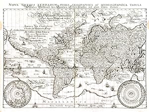
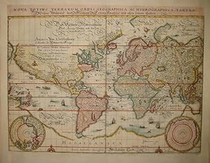
Nova totius terrarum orbis, anno 1638, Kst., Merian Matthäus Kst.- Karte, b. Merian aus "Nieuwe Archontologia cosmica", "Nova totius terrarum Orbis Geographica ac Hydrographica tabula .". 1638, 26 x 35,5 cm., gebräunt, div. restaurierte Randläsuren, hinterlegte Mittelfalz. Shirley, Nr. 345. Über der Karte Kopftitel mit lat. und deutschem Text. Am unteren Rand, jeweils in den Ecken, zwei Polkarten im Rund.
Erscheinungsdatum: 1638
Anbieter: Hammelburger Antiquariat, Hammelburg, Deutschland
Verkäuferbewertung 4 von 5 Sternen
Kunst / Grafik / Poster
EUR 690,00
Währung umrechnenEUR 30,00 für den Versand von Deutschland nach USAAnzahl: 1 verfügbar
In den WarenkorbKein Einband. Zustand: Ausreichend. Nova totius terrarum orbis, anno 1638, Kst., Merian Matthäus Kst.- Karte, b. Merian aus "Nieuwe Archontologia cosmica", "Nova totius terrarum Orbis Geographica ac Hydrographica tabula .". 1638, 26 x 35,5 cm., gebräunt, div. restaurierte Randläsuren, hinterlegte Mittelfalz. Shirley, Nr. 345. Über der Karte Kopftitel mit lat. und deutschem Text. Am unteren Rand, jeweils in den Ecken, zwei Polkarten im Rund.
-

RARE AND STRIKINGLY BEAUTIFUL WORLD MAP "Nova Totius Terrarum Orbis Geographica ac Hydrographica Tabula auct
Anbieter: Inter-Antiquariaat Mefferdt & De Jonge, Amsterdam, Niederlande
Verkäuferbewertung 2 von 5 Sternen
Kunst / Grafik / Poster
EUR 9.500,00
Währung umrechnenEUR 42,00 für den Versand von Niederlande nach USAAnzahl: 1 verfügbar
In den WarenkorbRARE AND STRIKINGLY BEAUTIFUL WORLD MAP "Nova Totius Terrarum Orbis Geographica ac Hydrographica Tabula auct. Iud. Hondio." Copper-engraved map from the "Théâtre Géographique Du Royaume de France" published in Paris by Melchior Tavernier, here in its second state of 1636. Coloured by a later hand. Size: 39,0 x 57,5 cm (plus margins). This double hemisphere map is based on Jodocus Hondius' world map of 1617 or possibly Jacob Honervogt's map of 1625, who also followed Jodocus Hondius'map.The ecliptic curves on Tavernier's map are reversed so that the line is north of the equator in the western hemisphere and east of south of the equator in the eastern hemisphere. The map by Hondius was the first to show Le Maire's Straits and the islands in the Pacific discovered by Jacob Le Maire and his explorations in New Guinea. In North America, Hondius' map was also one of the earliest to delineate Hudson's Bay, making special reference to Henry Hudson and the Dutch and English expeditions there up to 1612. Hondius also extends the full course of the St. Lawrence river which now curiously runs across the continent, terminating in a large lake. Decoratively, the map is one of the most attractive. The corners contain scenes of the four seasons. Ver or Spring, shows gardeners tending a formal Dutch garden; Aestas or Summer is the time for sheep-shearing; Autumn brings the grape harvest in for wine-pressing; and in Hyems or Winter skaters revel on a frozen lake. On either side of north and south celestial hemispheres are recumbent figures representing the four elements: Terra, Aqua, Ignis and Aer. The map in the cartouche on the right, is dedicated to the English mathematicians Henry Briggs and Edward Wright. Literature: The Mapping of the World, Rodney Shirley no. 337, plate 230. Price: Euro 9.500,- (incl. frame).
-

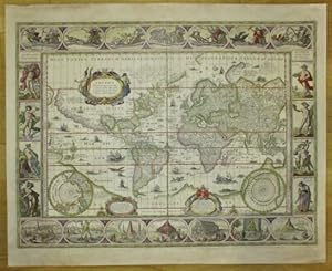
Nova Totius Terrarum Orbis Geographica ac Hydrographica Tabula.
Erscheinungsdatum: 1652
Anbieter: Altea Antique Maps, London, Vereinigtes Königreich
Verbandsmitglied: ABA ILAB PBFA
Verkäuferbewertung 5 von 5 Sternen
Karte
EUR 24.077,73
Währung umrechnenEUR 40,91 für den Versand von Vereinigtes Königreich nach USAAnzahl: 1 verfügbar
In den WarenkorbAmsterdam, 1652. Original colour. 445 x 560mm. Restoration to margin and centre fold. This magnificent planisphere manages to include 30 separate illustrations in its panels. Along the top and bottom are equestrian portraits of the Twelve Cćsars of Tacitus. The four corners feature female allegorical figures of the Continents, with Europe as a shepherdess, Asia seated on a camel, Africa on a crocodile and America on an armadillo! The left border has prospects of Rome, Amsterdam, Jerusalem and Tunis, interspersed with illustrations of European, Asian and African dress. The right border is given over completely to America: the prospects of Mexico City, Havana, Pernambuco and Todos os Santos Bay are separated by vignettes of North American natives, South Americans and the giants of the Magellan Strait. Originally published in 1639, most of the cartography has been copied from Blaeu, although Arctic America has been extended, as has the St Lawrence River. This state has the date 1652, the year of Visscher's death, added. SHIRLEY: 350.
-
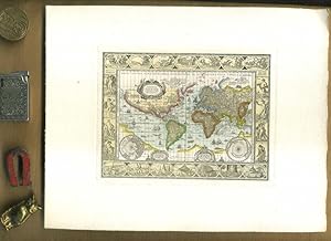
Nova Totius Terrarum Orbis Geographica ac Hydrographica Tabula. Koloriertes Faksimile einer Kupferstichkarte von Piscator, 1639. 46 x 57 cm.
Erscheinungsdatum: 1639
Sprache: Deutsch
Anbieter: Antiquariat Daniel Schramm e.K., Kiel, Deutschland
Verkäuferbewertung 4 von 5 Sternen
EUR 120,00
Währung umrechnenEUR 60,00 für den Versand von Deutschland nach USAAnzahl: 1 verfügbar
In den WarenkorbZustand: 0. Weltkarte in Mercator-Projektion mit zwei Inset-Polkarten, sowie allegorischen Darstellungen und 8 kleinen Stadtansichten im Aussenrand.- World maps - Nova Totius Terrarum Orbis Geographica ac Hydrographica Tabula. Colored facsimile of a copper engraving map by Piscator, 1639. 46 x 57 cm. World map in Mercator projection with two inset pole maps, as well as allegorical depictions and 8 small city views in the outer margin. Sprache: Deutsch Gewicht in Gramm: 500.
-

Kupferstich- Karte, b. Merian aus "Neuwe Archontologia cosmica", "Nova totius terrarum Orbis Geographica ac Hydrographica tabula .".
Sprache: Deutsch
Anbieter: Antiquariat Clemens Paulusch GmbH, Berlin, Deutschland
Verkäuferbewertung 5 von 5 Sternen
Karte
EUR 1.500,00
Währung umrechnenEUR 26,90 für den Versand von Deutschland nach USAAnzahl: 1 verfügbar
In den Warenkorb1638, 26 x 35,5 Shirley, Nr. 345. Über der Karte Kopftitel mit lat. und deutschem Text. Am unteren Rand, jeweils in den Ecken, zwei Polkarten im Rund.
-

Kompletter uniformer Blaeu-Satz mit der Weltkarte und den Erdteilen Afrika, Europa, Asien und Amerika - A set of the world and four continents - 'Nova Totius Terrarum Orbis Geographica ac Hydrographica Tabula' - 'Europa recens descripta' - 'Africae nova descriptio' - 'Asia noviter delineata' - 'Americae nova Tabula':.
Sprache: Deutsch
Anbieter: Antiquariat Norbert Haas, Bedburg-Hau, Deutschland
Verkäuferbewertung 5 von 5 Sternen
Karte
EUR 28.000,00
Währung umrechnenEUR 40,00 für den Versand von Deutschland nach USAAnzahl: 1 verfügbar
In den Warenkorb5 kololorierte Kupferstiche v. Josua van den Ende aus Atlantis Appendix, Sive Pars Altera b. Willem Janszoon Blaeu in Amsterdam, 1630, je 41 x 55,5 Shirley, The Mapping of the World - Early Printed World Maps 1472 - 1700, Nr. 255 (4. state); State 4; Burden, The Mapping of North America, Nr. 189 (3.state); Betz, The Mapping of Africa, Nr. 57 (2. state); Borri, L' Europa Nell' Antica Cartografia, Nr. 40.5; van der Krogt, Koeman's Atlantes Neerlandici, Vol. II, 0001:2A, 2:011. - Diesen Zustand ohne Rückentext nicht bei v.d. Krogt (rare state without text verso).
![Bild des Verkäufers für Nova Totius Terrarum Orbis Geographica ac Hydrographi Emendata [Reprint] zum Verkauf von avelibro OHG](https://pictures.abebooks.com/inventory/md/md32035268451.jpg)