
Gesamtpreis (1 Artikel Artikel):
Versandziel:

pan: Karten (6 Ergebnisse)
Feedback
Direkt zu den wichtigsten Suchergebnissen
Suchfilter
Produktart
Zustand
- Alle
- Neu (Keine weiteren Ergebnisse entsprechen dieser Verfeinerung)
- Antiquarisch (6)
Einband
- alle Einbände
- Hardcover (Keine weiteren Ergebnisse entsprechen dieser Verfeinerung)
- Softcover (Keine weiteren Ergebnisse entsprechen dieser Verfeinerung)
Weitere Eigenschaften
- Erstausgabe (Keine weiteren Ergebnisse entsprechen dieser Verfeinerung)
- Signiert (Keine weiteren Ergebnisse entsprechen dieser Verfeinerung)
- Schutzumschlag (Keine weiteren Ergebnisse entsprechen dieser Verfeinerung)
- Angebotsfoto (6)
Sprache (2)
Gratisversand
- Kostenloser Versand nach USA (Keine weiteren Ergebnisse entsprechen dieser Verfeinerung)
Land des Verkäufers
Verkäuferbewertung
-
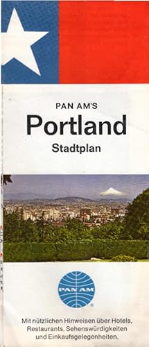
Pan Am s Portland Stadtplan 1968 Mit nützlichen Hinweisen über Hotels, Restaurants und Sehenswürdigkeiten.
Erscheinungsdatum: 1968
Sprache: Deutsch
Anbieter: Schürmann und Kiewning GbR, Naumburg, Deutschland
Verkäuferbewertung 5 von 5 Sternen

Karte
EUR 8,95
Währung umrechnenEUR 9,00 für den Versand von Deutschland nach USAAnzahl: 1 verfügbar
In den Warenkorbaufgefaltet: 46 x 57 cm. Zustand: Gut. 1 Karte, beidseitig bedruckt; Sprache: Deutsch Gewicht in Gramm: 60.
-
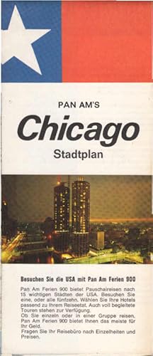
Pan Am s Chicago Stadtplan 1968 Mit nützlichen Hinweisen über Hotels, Restaurants und Sehenswürdigkeiten.
Erscheinungsdatum: 1968
Sprache: Deutsch
Anbieter: Schürmann und Kiewning GbR, Naumburg, Deutschland
Verkäuferbewertung 5 von 5 Sternen
Karte
EUR 8,95
Währung umrechnenEUR 9,00 für den Versand von Deutschland nach USAAnzahl: 1 verfügbar
In den Warenkorbaufgefaltet: 46 x 57 cm. Zustand: Gut. 1 Karte, beidseitig bedruckt; Sprache: Deutsch Gewicht in Gramm: 60.
-
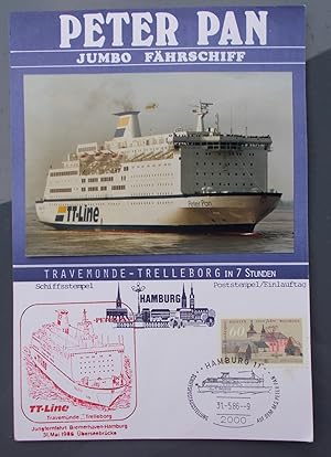
Peter Pan Jumbo Fährschiff Travemünde-Trelleborg - Schiffstempel Jungfernfahrt Bremerhaven-Hamburg 31. Mai 1986 Überseebrücke
Erscheinungsdatum: 1986
Anbieter: Buchstube Tiffany, Barsbüttel, Deutschland
Verkäuferbewertung 3 von 5 Sternen

Karte
EUR 10,00
Währung umrechnenEUR 10,00 für den Versand von Deutschland nach USAAnzahl: 1 verfügbar
In den WarenkorbKein Einband. Zustand: Gut bis sehr gut.
-
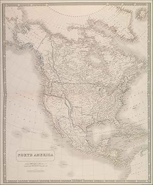
'NORTH AMERICA'. Texas is shown as an independent Republic with the Pan-handle. There is a 'note' stating that the whole of the territory, to the west of the Rocky Mountains, between the Mexican and the Russian boundaries, is claimed by both Gt. Britain & the United States
Verlag: Johnston, A.K. 1843, 1843
Anbieter: Garwood & Voigt, Sevenoaks, Vereinigtes Königreich
Verkäuferbewertung 5 von 5 Sternen
Karte
EUR 788,26
Währung umrechnenEUR 41,21 für den Versand von Vereinigtes Königreich nach USAAnzahl: 1 verfügbar
In den WarenkorbZustand: Fine. 60x50cm. Outline colour. Excellent condition.
-
Routes of Pan American World Airways System / Your Clipper Trip.
Erscheinungsdatum: 1952
Anbieter: Geographicus Rare Antique Maps, Brooklyn, NY, USA
Verbandsmitglied: ABAA ESA ILAB
Verkäuferbewertung 5 von 5 Sternen
Karte
EUR 253,20
Währung umrechnenEUR 14,93 für den Versand innerhalb von/der USAAnzahl: 1 verfügbar
In den WarenkorbVery good. Light wear along original fold lines. Slight loss at a few fold intersections. Size 17.5 x 31.25 Inches. A striking 1952 world map illustrating the routes of Pan American World Airways. A towering pioneer in the aviation industry, the company was among the first to offer reliable international passenger service and, by the 1950s, had the most developed global network of any American airline. A Closer Look A Mercator projection world map centered on the United States is overlaid with lines depicting the company's routes, with flight duration and distances (in kilometers and miles) noted. Relief is shown by shading and color, with the height of major peaks recorded. Among destinations, the greatest density lies in Central and South America (where the company first cut its teeth) and Western Europe. Many routes originated in New York City at the New York International Airport (then commonly known as Idlewild), later renamed John F. Kennedy International Airport. The geographical divisions of the early Cold War are readily apparent, as the Soviet Union, Eastern Europe, and China (though not Hong Kong) sit beyond the scope of Pan Am's impressive network. The verso includes panels touting the airline's amenities, affordability, and destinations. Publication History and Census This map was prepared by Pan American World Airways and Jeppesen and Company and was published in 1952. There are two variants of the map, identical on the recto but with different illustrations and text on the verso; here, with the title 'Your Clipper Trip' with a red ink motif and an alternate printing with the title 'Destinations Unlimited' and a dark blue ink motif. The trademark on the verso suggests that this motif might have been printed in 1954 with the 1952 map on the recto. Subsequent editions of Pan Am world route maps with the title 'Destinations Unlimited' were published in 1956, 1959, and 1961, while the 'Your Clipper Trip' variant was printed in a single edition. Regardless of verso content, the map is listed among the holdings of 8 institutions in the OCLC. References: OCLC 639166181, 1130727014.
-

Pan American Airways System. World's Most Experienced Airline.
Erscheinungsdatum: 1968
Anbieter: Geographicus Rare Antique Maps, Brooklyn, NY, USA
Verbandsmitglied: ABAA ESA ILAB
Verkäuferbewertung 5 von 5 Sternen
Karte
EUR 987,49
Währung umrechnenEUR 14,93 für den Versand innerhalb von/der USAAnzahl: 1 verfügbar
In den WarenkorbVery good. Closed tear extending one-and-one-half (1.5) inches from top edge professionally repaired on verso. Closed margin tears professionally repaired on verso. Size 33 x 59 Inches. Published at the height of Pan American's success, this is a 1968 Pan American Airways (Pan Am) route map of the world. At the time, Pan American operated flights to eighty-six countries on six continents. Red lines highlight Pan American's routes across the globe, with numbers providing each route's distance in miles and kilometers. Pan Am's impressive network connected its hub at John F. Kennedy Airport in New York City with the rest of the world. The airline serviced islands throughout the Caribbean, South America, western and central Europe, the Middle East and East Asia, and several Pacific islands. Publication History and Census This cartography for this map was created by John Philip and the art was created by Paul John Brown. This map was originally published in 1956, with the present edition bearing corrections up to January 1, 1968. We note five examples of the original 1956 edition cataloged in OCLC, but we have been unable to locate any cataloged examples of the present 1968 edition. Examples of the 1956 and 1964 editions are part of the David Rumsey Map Collection. References: OCLC 648933109.
