Gesamtpreis (1 Artikel Artikel):
Versandziel:

schlesien polen: Karten (16 Ergebnisse)
Feedback
Direkt zu den wichtigsten Suchergebnissen
Suchfilter
Produktart
- Alle Product Types
- Bücher (99)
- Magazine & Zeitschriften (Keine weiteren Ergebnisse entsprechen dieser Verfeinerung)
- Comics (Keine weiteren Ergebnisse entsprechen dieser Verfeinerung)
- Noten (Keine weiteren Ergebnisse entsprechen dieser Verfeinerung)
- Kunst, Grafik & Poster (35)
- Fotografien (Keine weiteren Ergebnisse entsprechen dieser Verfeinerung)
- Karten (16)
- Manuskripte & Papierantiquitäten (90)
Zustand
- Alle
- Neu (Keine weiteren Ergebnisse entsprechen dieser Verfeinerung)
- Antiquarisch (16)
Einband
- alle Einbände
- Hardcover (Keine weiteren Ergebnisse entsprechen dieser Verfeinerung)
- Softcover (Keine weiteren Ergebnisse entsprechen dieser Verfeinerung)
Weitere Eigenschaften
- Erstausgabe (1)
- Signiert (Keine weiteren Ergebnisse entsprechen dieser Verfeinerung)
- Schutzumschlag (Keine weiteren Ergebnisse entsprechen dieser Verfeinerung)
- Angebotsfoto (16)
Sprache (4)
Preis
- Beliebiger Preis
- Weniger als EUR 20 (Keine weiteren Ergebnisse entsprechen dieser Verfeinerung)
- EUR 20 bis EUR 45
- Mehr als EUR 45
Gratisversand
- Kostenloser Versand nach USA (Keine weiteren Ergebnisse entsprechen dieser Verfeinerung)
Land des Verkäufers
Verkäuferbewertung
-

Norddeutschland Mecklenburg-Vorpommern Brandenburg Niedersachsen Schlesien / Polska / Polen / Poland
Verlag: Paris, 1758
Sprache: Französisch
Anbieter: Antiquariat Steffen Völkel GmbH, Seubersdorf, Deutschland
Verkäuferbewertung 5 von 5 Sternen

Karte
EUR 49,99
Währung umrechnenEUR 32,00 für den Versand von Deutschland nach USAAnzahl: 1 verfügbar
In den WarenkorbBild-Maße: ca. 31 x 44 cm. -- Seltene grenzkolorierte Kupferstich-Karte aus der Zeit des 7-jährigen Krieges. -- gut erhalten. || Rare border-colored engraved map from the time of the Seven Years' War. -- in good condition. Sprache: Französisch Gewicht in Gramm: 15.
-

"La Basse Silesie" - Niederschlesien Schlesien Glogau Wartenberg Poland Polska Polen map Karte
Verlag: Paris, 1756
Sprache: Französisch
Anbieter: Antiquariat Steffen Völkel GmbH, Seubersdorf, Deutschland
Verkäuferbewertung 5 von 5 Sternen
Karte
EUR 49,99
Währung umrechnenEUR 32,00 für den Versand von Deutschland nach USAAnzahl: 1 verfügbar
In den WarenkorbOriginal altkolorierte Kupferstich-Karte von Georges Luis Le Rouge (1707-1790) von ca. 1756 - Blattmasse: ca. 33,5 x 25 cm - gut erhalten. | original hand colored copper engraved map by Georges Luis Le Rouge (1707-1790) from circa 1756 - size of sheet: circa 13.2 x 9.8 inches - good condition. | Dies ist ein Original! - Kein Nachdruck! - Keine Kopie! -- This is an original! - No copy! - No reprint! Sprache: Französisch Gewicht in Gramm: 10.
-
"Boheme, Moravie, Saxonie, Lusace, Silesie / Königreich Böhmen, Margr: Mähren, Fürst. Saxen, Marg: Lausnitz, Herzog: Schlesien" - Böhmen / Schlesien / Mähren / Czech / Polska / Polen / Poland / Sachsen / Lausitz
Verlag: Augsburg, 1760
Sprache: Deutsch
Anbieter: Antiquariat Steffen Völkel GmbH, Seubersdorf, Deutschland
Verkäuferbewertung 5 von 5 Sternen
Karte Erstausgabe
EUR 39,99
Währung umrechnenEUR 32,00 für den Versand von Deutschland nach USAAnzahl: 1 verfügbar
In den WarenkorbBlatt-Format: ca.11x14 cm - Altkolorierte Kupferstich-Kartevon ca.1760. || Original old-colored engraved map from circa 1760. -- gut erhalten. / in very good condition. || Dies ist ein Original! - Kein Nachdruck! - Keine Kopie! -- This is an original! - No copy! - No reprint! Sprache: Deutsch Gewicht in Gramm: 5.
-

"Glatz die Haupt-Stadt der Grafschafft gleiches nahmens, mitt Nahe anligender Gegend." - Glatz Klodzko Schlesien Niederschlesien Polska Polen Poland
Verlag: Augsburg, 1759
Sprache: Deutsch
Anbieter: Antiquariat Steffen Völkel GmbH, Seubersdorf, Deutschland
Verkäuferbewertung 5 von 5 Sternen
Karte
EUR 39,99
Währung umrechnenEUR 32,00 für den Versand von Deutschland nach USAAnzahl: 1 verfügbar
In den WarenkorbAltkolorierte Kupferstich-Karte von Georg Christoph Kilian von 1759. -- Blatt-Maße: ca. 18 x 29 cm. -- am oberen Rand mit kleinen hinterlegten Wurmspuren, im unteren Mittelbug teils hinterlegt, etwas knapprandig, sonst gut erhalten. || Old colored engraved map by Georg Christoph Kilian from 1759. -- with small deposited worm holes on the upper margin, deposited on the lower part of the centerfold, with narrow margins, otherwise in good condition. || Dies ist ein Original! - Kein Nachdruck! - Keine Kopie! -- This is an original! - No copy! - No reprint! Sprache: Deutsch Gewicht in Gramm: 10.
-

"L'Allemagne dressée sue les Observations de Tycho-Brahe de Kepler de Snellius sue celles de Messieres de l'Academie Royale des Sciences etc. sur Zeiller et autres Auteurs anciens ou modernes" - Deutsches Reich Böhmen Österreich Schweiz Holland Bohemia Silesia Schlesien Polska Polen Polande Österreich Austria Deutschland
Verlag: Amsterdam, Covens & Mortier c. 1750., 1750
Sprache: Französisch
Anbieter: Antiquariat Steffen Völkel GmbH, Seubersdorf, Deutschland
Verkäuferbewertung 5 von 5 Sternen
Karte
EUR 99,99
Währung umrechnenEUR 32,00 für den Versand von Deutschland nach USAAnzahl: 1 verfügbar
In den WarenkorbBlatt-Maße: ca. 53 x 66 cm. -- Altkolorierte Kupferstich-Karte. -- mit kleinen Plattenfehler, sonst gut erhalten. || Old colored engraved map. -- with a minor plate defect, otherwise in good condition. Sprache: Französisch Gewicht in Gramm: 30.
-

"Le Royaume de Boheme, le Duche de Silesie, et les Marquisats de Moravie et Lusace" - Bohemia Böhmen Schlesien Mähren Moravia Czech Polska Polen Poland
Verlag: Venezia, Santini & Remondini, 1777
Sprache: Französisch
Anbieter: Antiquariat Steffen Völkel GmbH, Seubersdorf, Deutschland
Verkäuferbewertung 5 von 5 Sternen
Karte
EUR 119,99
Währung umrechnenEUR 32,00 für den Versand von Deutschland nach USAAnzahl: 1 verfügbar
In den WarenkorbGroßformatige altkolorierte Kupferstich-Karte von 1777 -- Blatt-Maße: ca. 52,5 x 75,5 cm. -- gut erhalten. || Large old colored engraved map from 1777. -- in good condition. || Francesco Santini was a Venetian publisher. He acquired the printing plates of Vaugondy's Atlas Universel, a commercial and cartographic success, with widespread influence on mapmakers throughout Europe. Together with his brother Paolo, he commissioned a new set of plates and reissued the atlas in 1776. In the following years, Paolo Santini assigned all his publication rights to M. Remondini, who in 1777 reissued the same atlas, but with his name. Sprache: Französisch Gewicht in Gramm: 550.
-

"Des Herzogthums Schlesien Fürstenthümer Schweidnitz u. Münsterberg mit dem preussischen Theile des Fürstenthums Neyss oder die zur Breßlauischen Kammer gehörigen Kreise Schweidnitz, Striegau, Blkenhayn, Landshut, Reichenbach, Münsterberg, Frankenstein, Neyss und Grottkau Nro. 109" - Schlesien Silesia Nysa Schweidnitz Polen Polska Poland
Verlag: Wien, 1791
Sprache: Deutsch
Anbieter: Antiquariat Steffen Völkel GmbH, Seubersdorf, Deutschland
Verkäuferbewertung 5 von 5 Sternen
Karte
EUR 49,99
Währung umrechnenEUR 32,00 für den Versand von Deutschland nach USAAnzahl: 1 verfügbar
In den WarenkorbOriginal altkolorierte Kupferstich-Karte von Franz Johann Joseph Reilly (1766-1820) von ca. 1790. -- Blattmaße: ca. 29 x 38,5 cm. Plattenmaße: ca. 22 x 33 cm. -- teils leicht wasserfleckig, sonst gut erhalten. || Original handcolored copper engraved map by Franz Johann Joseph Reilly (1766-1820) from circa 1790. -- Some slightly water stained, otherwise in good condition. Sprache: Deutsch Gewicht in Gramm: 1500.
-

"Marchionatus Brandenburgi et Ducatus Pomeranie tabula quam est pars septentrionalis Circuli Saxoniae Superioris" - Brandenburg Mecklenburg-Vorpommern / Polska Polen Poland / Silesia Schlesien
Verlag: Amsterdam, Covens & Mortier ca. 1750., 1750
Sprache: Französisch
Anbieter: Antiquariat Steffen Völkel GmbH, Seubersdorf, Deutschland
Verkäuferbewertung 5 von 5 Sternen
Karte
EUR 149,99
Währung umrechnenEUR 32,00 für den Versand von Deutschland nach USAAnzahl: 1 verfügbar
In den WarenkorbBlatt-Maße: ca. 53 x 66 cm. -- Altkolorierte Kupferstich-Karte. -- gut erhalten. || Old colored engraved map. -- in good condition. Sprache: Französisch Gewicht in Gramm: 30.
-

"Le Marquisat de Basse Lusace divisee en ses cercles, seigneuries et senechaussees &c." - Niederlausitz Lausitz Peitz Cottbus Guben / Schlesien Silesia Polska Polen Poland
Verlag: Amsterdam, Covens u. Mortier ca. 1750., 1750
Sprache: Französisch
Anbieter: Antiquariat Steffen Völkel GmbH, Seubersdorf, Deutschland
Verkäuferbewertung 5 von 5 Sternen
Karte
EUR 149,99
Währung umrechnenEUR 32,00 für den Versand von Deutschland nach USAAnzahl: 1 verfügbar
In den WarenkorbBlatt-Maße: ca. 53 x 66 cm. -- Altkolorierte Kupferstich-Karte. -- gut erhalten. || Old colored engraved map. -- in good condition. Sprache: Französisch Gewicht in Gramm: 30.
-

Sup.s et Inferioris Ducatus Silesiae in suos XVII minores principatus et dominia divisi nova tabula" - Schlesien Silesia Wroclaw / Polska Polen Poland // Mit Stadtplan von Breslau in oberer Kartusche.
Verlag: Aachen, Amsterdam, Covens u. Mortier, 1741
Sprache: Französisch
Anbieter: Antiquariat Steffen Völkel GmbH, Seubersdorf, Deutschland
Verkäuferbewertung 5 von 5 Sternen
Karte
EUR 350,00
Währung umrechnenEUR 32,00 für den Versand von Deutschland nach USAAnzahl: 1 verfügbar
In den WarenkorbBlatt-Maße: ca. 53 x 66 cm. -- Altkolorierte Kupferstich-Karte. -- gut erhalten. || Old colored engraved map. -- in good condition. Sprache: Französisch Gewicht in Gramm: 30.
-

"Charte von Böhmen, Mähren und Oestr. Schlesien" - Böhmen Bohemia Schlesien Silesia / Polska / Polen / Poland
Verlag: ca. 1820., 1820
Sprache: Deutsch
Anbieter: Antiquariat Steffen Völkel GmbH, Seubersdorf, Deutschland
Verkäuferbewertung 5 von 5 Sternen
Karte
EUR 29,99
Währung umrechnenEUR 32,00 für den Versand von Deutschland nach USAAnzahl: 1 verfügbar
In den WarenkorbAltkolorierte Kupferstich-Karte von ca. 1820. -- Blatt-Format: ca. 26 x 30 cm. -- gut erhalten. || Old colored engraved map from c. 1820. -- in very good condition. Sprache: Deutsch Gewicht in Gramm: 15.
-

"Schlesien mit seinen Fürstenthumern und Herrschafften" - Silesia Schlesien Polska Polen Poland Wroclaw Opole
Verlag: Augsburg, 1759
Sprache: Deutsch
Anbieter: Antiquariat Steffen Völkel GmbH, Seubersdorf, Deutschland
Verkäuferbewertung 5 von 5 Sternen
Karte
EUR 69,99
Währung umrechnenEUR 32,00 für den Versand von Deutschland nach USAAnzahl: 1 verfügbar
In den WarenkorbAltkolorierte Kupferstich-Karte von Georg Christoph Kilian von 1759. -- Blatt-Maße: ca. 18 x 29 cm. -- am oberen Rand mit kleinen hinterlegten Wurmspuren, sonst gut erhalten. || Old colored engraved map by Georg Christoph Kilian from 1759. -- with small deposited worm holes on the upper margin, otherwise in good condition. || Dies ist ein Original! - Kein Nachdruck! - Keine Kopie! -- This is an original! - No copy! - No reprint! Sprache: Deutsch Gewicht in Gramm: 10.
-

"Ober und Nieder Schlesien nebst der Grafschaft Glatz" - Schlesien Silesia Polen Polska Poland Karte map copper engraving
Verlag: ca. 1800., 1800
Sprache: Deutsch
Anbieter: Antiquariat Steffen Völkel GmbH, Seubersdorf, Deutschland
Verkäuferbewertung 5 von 5 Sternen
Karte
EUR 69,99
Währung umrechnenEUR 32,00 für den Versand von Deutschland nach USAAnzahl: 1 verfügbar
In den WarenkorbOriginal handkolorierte Kupferstich-Karte von ca. 1800 - von Daniel Friedrich Sotzmann (1754-1840) - Blatt-Maße: ca. 31 x 37 cm - Bild-Maße: ca. 26 x 29 cm - Außenrand leicht fleckig - sonst gut erhalten. -- original handcolored copper engraved map from around 1800 - from Daniel Friedrich Sotzmann (1754-1840) - outer margin slightly stained - otherwise in good condition. | Dies ist ein Original! - Kein Nachdruck! - Keine Kopie! -- This is an original! No copy! - No reprint! Sprache: Deutsch Gewicht in Gramm: 1550.
-

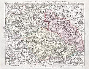
"Ducatus Silesiae Tabula Geographica generalis, statui hodierno, ei nempe qui postpacem Drezdensem locum obtinet, adaptata iustaque Graduatione rectificata per Tob. Maier." - Schlesien Silesia Poland Polska Polen Wroclaw Brzeg Karte map
Verlag: Nürnberg, Homann Erben, 1749
Sprache: Latein
Anbieter: Antiquariat Steffen Völkel GmbH, Seubersdorf, Deutschland
Verkäuferbewertung 5 von 5 Sternen
Karte
EUR 250,00
Währung umrechnenEUR 32,00 für den Versand von Deutschland nach USAAnzahl: 1 verfügbar
In den WarenkorbOriginal altkolorierte Kupferstich-Karte von Johann Baptist Homann (1664-1724) von 1749. -- Blatt-Maße: ca. 54,5 x 65 cm. -- teils leicht fleckig, sonst gut erhalten. || Original old colored engraved map by Johann Baptist Homann (1664-1724) from 1749. -- partly slightly stained, otherwise in good condition. || Dies ist ein Original! - Kein Nachdruck! - Keine Kopie! -- This is an original! No copy! - No reprint! la Gewicht in Gramm: 30.
-
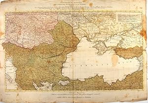
"Kriegstheater Oder Graenzkarte Oesterreichs, Russlands, Und Der Türkey,enthaltend Das Koenigreich Ungarn, Siebenbürgen, Moldau, Bessarabien, Walachey, Bulgarien, Servien, Bosnien, Sclavonien, Croatien, Albanien, Romanien, Macedonien, einen Theil Griechenlands, und des Archipelagus, die Dardanellen, das schwarze und asowische Meer, die Krim, Tatarey, Kuban, Circassien & & Nebst einem Theil von Russland, Polen, Schlesien, Maehren, Oesterreich, Steuermark & ".
Anbieter: Antiquariat Peter Fritzen, Speicher, Deutschland
Verkäuferbewertung 5 von 5 Sternen
Karte
EUR 400,00
Währung umrechnenEUR 12,00 für den Versand von Deutschland nach USAAnzahl: 1 verfügbar
In den WarenkorbKupferstich-Karte von Franz Müller nach C. Schütz bei Artaria, Wien, datiert 1788, altkoloriert. Ca. 40 x 70 cm (Karte), gesamt ca. 49 x 71 cm. Faltspuren, Einrisse, Flecken. Minimale Fehlstellen an den Eckfaltungen. Dörflinger, Johannes: Österreichische Karten des 18. Jahrhunderts. Bd. 1. Wien, 1984. S. 289 f. Karte zum Krieg Russlands gegen das Osmanenreich mit dem Schwarzen Meer und der Krim im Zentrum. Oberhalb der Einfassung mit 6-zeiligem Titel. Unterhalb der Einfassungslinie mit dem Vermerk "Nach den besten Karten und Handzeichnungen von C. Schütz entworfen 1788." (links) und "Gestochen von F. Müller" (rechts). Links unten mit Kaiserlichem Druckvermerk. In der Mitte unterhalb der Karte mit einer zweizeiligen "Erklaerung der Illumination: Roth ist oesterreichisch, Gelb russisch, Grün türkisch, Violet polnisch, Orangefarb venetianisch". Darunter mit dem Verlegervermerk "Zu finden in Wien bey Artaria Compagnie Kunsthändlern am Michaelerplatz". Oben rechts Meilenzeiger-Kartusche. Einblattdruck, selten.
-

DEUTSCHLAND- POLEN, SCHLESIEN 1749 HOMANN Titel: Ducatus Silesiae Tabula geographica generalis ; Dvcatvs Silesiae Tabula geographica generalis ; statui hodierno, ei nempe qui post pacem Dresdensem locum obtinet adaptata, iustaque Graduatione rectificata ; Le Duché De Silesie etc. per Tob. Maier. Norimbergae Impensis Homannorum Heredum.
Verlag: Homännische Erben [ca. 1749], Nürnberg, 1749
Anbieter: ANTIQUARIAT.WIEN Fine Books & Prints, Wien, Österreich
Verkäuferbewertung 5 von 5 Sternen
Karte
EUR 390,50
Währung umrechnenEUR 42,00 für den Versand von Österreich nach USAAnzahl: 1 verfügbar
In den WarenkorbLandkarte, map, original Kupferstich, Kupferst., flächen- u. grenzkol. - Maßstab in graph. Form [ca. 1:870 000], Nullmeridian: Ferro. - Titelkartusche oben rechts, Maßstabskartusche unten rechts, Platte ca. 56 x 48 cm Mayer, Tobias de 500 Landkarte.